Manalongon geodata
Manalongon (Central Visayas) is a populated place; located in Philippines in Asia/Manila (GMT+8) time zone. With population of 9,321 people, there are 661 cities with bigger population in this country. Compared to other cities in Philippines, 74.5% of cities are located further ↑North; 51.3% of cities are located further ←West and 60.8% of cities have higher elevation than Manalongon. Note1
Administrative division(s):
- Level 1: Central Visayas
- Level 2: Province of Negros Oriental
- Level 3: Santa Catalina


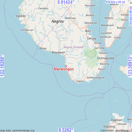
Manalongon GPS coordinates[2]
9° 13' 15.24" North, 122° 53' 9.6" East
| Map corner | latitude | longitude |
|---|---|---|
| Upper-left | 9.91424°, | 122.18288° |
| Center: | 9.2209°, | 122.886° |
| Lower-right: | 8.5262°, | 123.58913° |
| Map W x H: | 154.3×154.3 km | = 95.9×95.9mi |
| max Lat: | 20.78733° ⇑74.5% North |
| Manalongon: | 9.2209° |
| min Lat: | ⇓25.5% South 4.65442° |
| min Long | Manalongon | max Long |
| 117.04868° | 122.886° | 126.58417° |
| W 51.3%⇐ | ⇒48.7% E |
Elevation
Elevation of Manalongon is 16 m = 52 ft, and this is 71.9 m = 236 ft below average elevation for this country.
| Max E: |
2262 m = 7421 ft | 60.8% |
| Avg. | 87.9 m = 288 ft | |
| Manalongon | 16 m = 52 ft | |
Min E: |
-2 m = -7 ft | 39.2% |
See also: Philippines elevation on elevation.city.
Geographical zone
Manalongon is located in North Torrid zone (between Equator and Tropic of Cancer). Distance of Equator is 1025.3 km =637.1 mi to South.| Distance of | km | miles | from Manalongon |
|---|---|---|---|
| North Pole | 8981.8 | 5581 | to North |
| Arctic Circle | 6375.9 | 3961.8 | to North |
| Tropic Cancer | 1580.7 | 982.2 | to North |
| Equator | 1025.3 | 637.1 | to South |


Nearby cities:
15 places around Manalongon: (largest is in red/bold)
• Alangilan
6.5 km =4 mi,  353°
353°
• Amio
16.3 km =10.1 mi,  21°
21°
• Apoya
2.1 km =1.3 mi,  90°
90°
• Bayawan
18.4 km =11.4 mi,  330°
330°
• Bonawon
10.3 km =6.4 mi,  159°
159°
• Cabangahan
17.2 km =10.7 mi, 157°
• Caticugan
18.4 km =11.4 mi,  137°
137°
• Malabugas
20.8 km =12.9 mi,  322°
322°
• Maloh
21.3 km =13.2 mi,  149°
149°
• Maninihon
17.4 km =10.8 mi,  343°
343°
• Mantiquil
19 km =11.8 mi,  108°
108°
• Nagbalaye
3.3 km =2.1 mi, 340°
• Nangka
21.3 km =13.2 mi, 341°
• Sandolot
19.5 km =12.1 mi,  131°
131°
• Santa Catalina
12.8 km =8 mi, 348°
Sources, notices
• [Note1] Compared only with cities in Philippines existing in our database
• [Src1] Map data: © OpenStreetMap contributors (CC-BY-SA)
• [Src2] Other city data from geonames.org with taken over terms of usage.
• [Src3] Geographical zone / Annual Mean Temperature by Robert A. Rohde @ Wikipedia
