Nagtipunan geodata
Nagtipunan (Cagayan Valley) is a populated place; located in Philippines in Asia/Manila (GMT+8) time zone. With population of 5,682 people, there are 1123 cities with bigger population in this country. Compared to other cities in Philippines, 89.5% of cities are located further ↓South; 65.5% of cities are located further →East and 89.1% of cities have lower elevation than Nagtipunan. Note1
Administrative division(s):
- Level 1: Cagayan Valley
- Level 2: Province of Quirino
- Level 3: Nagtipunan


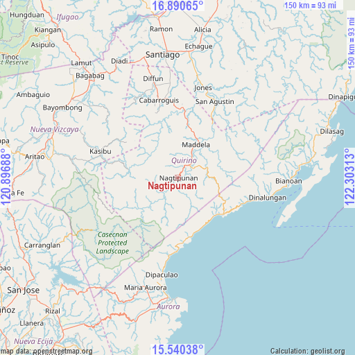
Nagtipunan GPS coordinates[2]
16° 13' 0.012" North, 121° 36' 0" East
| Map corner | latitude | longitude |
|---|---|---|
| Upper-left | 16.89065°, | 120.89688° |
| Center: | 16.21667°, | 121.6° |
| Lower-right: | 15.54038°, | 122.30313° |
| Map W x H: | 150.1×150.1 km | = 93.3×93.3mi |
| max Lat: | 20.78733° ⇑10.5% North |
| Nagtipunan: | 16.21667° |
| min Lat: | ⇓89.5% South 4.65442° |
| min Long | Nagtipunan | max Long |
| 117.04868° | 121.6° | 126.58417° |
| W 34.5%⇐ | ⇒65.5% E |
Elevation
Elevation of Nagtipunan is 204 m = 669 ft, and this is 116.1 m = 381 ft above average elevation for this country.
| Max E: |
2262 m = 7421 ft | 10.9% |
| Nagtipunan | 204 m 669 ft | |
| Avg. | 87.9 m = 288 ft | |
Min E: |
-2 m = -7 ft | 89.1% |
See also: Philippines elevation on elevation.city.
Geographical zone
Nagtipunan is located in North Torrid zone (between Equator and Tropic of Cancer). Distance of this Northern Tropic circle is 802.8 km =498.8 mi to North.| Distance of | km | miles | from Nagtipunan |
|---|---|---|---|
| North Pole | 8203.9 | 5097.7 | to North |
| Arctic Circle | 5598 | 3478.4 | to North |
| Tropic Cancer | 802.8 | 498.8 | to North |
| Equator | 1803.1 | 1120.4 | to South |


Nearby cities:
15 places around Nagtipunan: (largest is in red/bold)
• Aglipay
30.6 km =19 mi,  9°
9°
• Belance
37.6 km =23.4 mi,  264°
264°
• Cabarroguis
33.8 km =21 mi,  345°
345°
• Dibuluan
37.9 km =23.5 mi,  27°
27°
• Diffun
42.7 km =26.5 mi, 346°
• Dinalongan
39.1 km =24.3 mi,  102°
102°
• Dumabato
15.4 km =9.6 mi,  43°
43°
• Jones
39.4 km =24.5 mi,  16°
16°
• Kasibu
34.3 km =21.3 mi,  288°
288°
• Maddela
16.6 km =10.3 mi, 33°
• Masaya Sur
35.2 km =21.9 mi, 26°
• Minuri
44.4 km =27.6 mi, 37°
• Pangal Sur
43.3 km =26.9 mi, 9°
• Quezon
47.5 km =29.5 mi,  311°
311°
• Saguday
36.5 km =22.7 mi, 353°
Sources, notices
• [Note1] Compared only with cities in Philippines existing in our database
• [Src1] Map data: © OpenStreetMap contributors (CC-BY-SA)
• [Src2] Other city data from geonames.org with taken over terms of usage.
• [Src3] Geographical zone / Annual Mean Temperature by Robert A. Rohde @ Wikipedia
