Masaya Sur geodata
Masaya Sur (Cagayan Valley) is a populated place; located in Philippines in Asia/Manila (GMT+8) time zone. With population of 5,523 people, there are 1151 cities with bigger population in this country. Compared to other cities in Philippines, 90.9% of cities are located further ↓South; 63.4% of cities are located further →East and 82.5% of cities have lower elevation than Masaya Sur. Note1
Administrative division(s):
- Level 1: Cagayan Valley
- Level 2: Province of Isabela
- Level 3: San Agustin


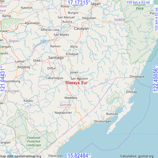
Masaya Sur GPS coordinates[2]
16° 30' 0.612" North, 121° 44' 50.748" East
| Map corner | latitude | longitude |
|---|---|---|
| Upper-left | 17.17315°, | 121.04431° |
| Center: | 16.50017°, | 121.74743° |
| Lower-right: | 15.82484°, | 122.45056° |
| Map W x H: | 149.9×149.9 km | = 93.1×93.1mi |
| max Lat: | 20.78733° ⇑9.1% North |
| Masaya Sur: | 16.50017° |
| min Lat: | ⇓90.9% South 4.65442° |
| min Long | Masaya Sur | max Long |
| 117.04868° | 121.74743° | 126.58417° |
| W 36.6%⇐ | ⇒63.4% E |
Elevation
Elevation of Masaya Sur is 111 m = 364 ft, and this is 23.1 m = 76 ft above average elevation for this country.
| Max E: |
2262 m = 7421 ft | 17.5% |
| Masaya Sur | 111 m 364 ft | |
| Avg. | 87.9 m = 288 ft | |
Min E: |
-2 m = -7 ft | 82.5% |
See also: Philippines elevation on elevation.city.
Geographical zone
Masaya Sur is located in North Torrid zone (between Equator and Tropic of Cancer). Distance of this Northern Tropic circle is 771.3 km =479.3 mi to North.| Distance of | km | miles | from Masaya Sur |
|---|---|---|---|
| North Pole | 8172.4 | 5078.1 | to North |
| Arctic Circle | 5566.5 | 3458.9 | to North |
| Tropic Cancer | 771.3 | 479.3 | to North |
| Equator | 1834.6 | 1140 | to South |


Nearby cities:
15 places around Masaya Sur: (largest is in red/bold)
• Aglipay
11 km =6.8 mi,  263°
263°
• Batal
26 km =16.2 mi,  323°
323°
• Cabarroguis
24.2 km =15 mi,  272°
272°
• Dibuluan
2.8 km =1.7 mi,  41°
41°
• Diffun
27.6 km =17.1 mi,  291°
291°
• Dumabato
21 km =13 mi,  193°
193°
• Echague
24 km =14.9 mi,  341°
341°
• Jones
7.9 km =4.9 mi, 323°
• Maddela
18.9 km =11.7 mi,  200°
200°
• Minuri
12 km =7.5 mi,  72°
72°
• Pangal Sur
13.9 km =8.6 mi, 323°
• Ramos West
26.3 km =16.3 mi,  327°
327°
• Saguday
20.1 km =12.5 mi,  283°
283°
• San Guillermo
25.9 km =16.1 mi,  14°
14°
• Soyung
23.9 km =14.9 mi, 338°
Sources, notices
• [Note1] Compared only with cities in Philippines existing in our database
• [Src1] Map data: © OpenStreetMap contributors (CC-BY-SA)
• [Src2] Other city data from geonames.org with taken over terms of usage.
• [Src3] Geographical zone / Annual Mean Temperature by Robert A. Rohde @ Wikipedia
