Minuri geodata
Minuri (Cagayan Valley) is a populated place; located in Philippines in Asia/Manila (GMT+8) time zone. With population of 2,546 people, there are 3217 cities with bigger population in this country. Compared to other cities in Philippines, 91.1% of cities are located further ↓South; 62% of cities are located further →East and 84.6% of cities have lower elevation than Minuri. Note1


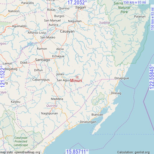
Minuri GPS coordinates[2]
16° 31' 56.388" North, 121° 51' 19.152" East
| Map corner | latitude | longitude |
|---|---|---|
| Upper-left | 17.2052°, | 121.1522° |
| Center: | 16.53233°, | 121.85532° |
| Lower-right: | 15.85711°, | 122.55845° |
| Map W x H: | 149.9×149.9 km | = 93.1×93.1mi |
| max Lat: | 20.78733° ⇑8.9% North |
| Minuri: | 16.53233° |
| min Lat: | ⇓91.1% South 4.65442° |
| min Long | Minuri | max Long |
| 117.04868° | 121.85532° | 126.58417° |
| W 38%⇐ | ⇒62% E |
Elevation
Elevation of Minuri is 131 m = 430 ft, and this is 43.1 m = 141 ft above average elevation for this country.
| Max E: |
2262 m = 7421 ft | 15.4% |
| Minuri | 131 m 430 ft | |
| Avg. | 87.9 m = 288 ft | |
Min E: |
-2 m = -7 ft | 84.6% |
See also: Philippines elevation on elevation.city.
Geographical zone
Minuri is located in North Torrid zone (between Equator and Tropic of Cancer). Distance of this Northern Tropic circle is 767.7 km =477 mi to North.| Distance of | km | miles | from Minuri |
|---|---|---|---|
| North Pole | 8168.8 | 5075.9 | to North |
| Arctic Circle | 5563 | 3456.7 | to North |
| Tropic Cancer | 767.7 | 477 | to North |
| Equator | 1838.2 | 1142.2 | to South |


Nearby cities:
15 places around Minuri: (largest is in red/bold)
• Aglipay
22.9 km =14.2 mi,  257°
257°
• Angadanan
27.3 km =17 mi,  335°
335°
• Dibuluan
9.8 km =6.1 mi, 261°
• Dicamay
29.5 km =18.3 mi,  32°
32°
• Dumabato
29.1 km =18.1 mi,  214°
214°
• Echague
27.1 km =16.8 mi,  315°
315°
• Jones
16.5 km =10.3 mi,  279°
279°
• Maddela
27.9 km =17.3 mi,  220°
220°
• Malasin
31.2 km =19.4 mi,  345°
345°
• Masaya Sur
12 km =7.5 mi,  252°
252°
• Pangal Sur
21.2 km =13.2 mi,  290°
290°
• Ramos West
31.7 km =19.7 mi,  305°
305°
• Saguday
31.1 km =19.3 mi,  272°
272°
• San Guillermo
22 km =13.7 mi, 347°
• Soyung
27.5 km =17.1 mi, 312°
Sources, notices
• [Note1] Compared only with cities in Philippines existing in our database
• [Src1] Map data: © OpenStreetMap contributors (CC-BY-SA)
• [Src2] Other city data from geonames.org with taken over terms of usage.
• [Src3] Geographical zone / Annual Mean Temperature by Robert A. Rohde @ Wikipedia
