Aglipay geodata
Aglipay (Cagayan Valley) is a seat of a third-order administrative division; located in Philippines in Asia/Manila (GMT+8) time zone. In our database, there are 4166 cities with bigger population. Compared to other cities in Philippines, 90.8% of cities are located further ↓South; 64.7% of cities are located further →East and 82.8% of cities have lower elevation than Aglipay. Note1


Aglipay GPS coordinates[2]
16° 29' 20.04" North, 121° 38' 42" East
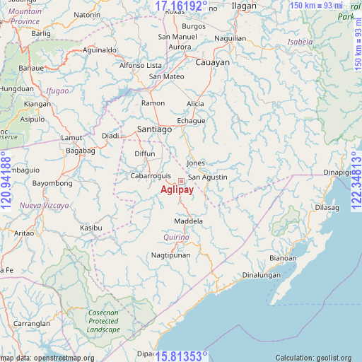
| Map corner | latitude | longitude |
|---|---|---|
| Upper-left | 17.16192°, | 120.94188° |
| Center: | 16.4889°, | 121.645° |
| Lower-right: | 15.81353°, | 122.34813° |
| Map W x H: | 149.9×149.9 km | = 93.1×93.1mi |
| max Lat: | 20.78733° ⇑9.2% North |
| Aglipay: | 16.4889° |
| min Lat: | ⇓90.8% South 4.65442° |
| min Long | Aglipay | max Long |
| 117.04868° | 121.645° | 126.58417° |
| W 35.3%⇐ | ⇒64.7% E |
Elevation
Elevation of Aglipay is 114 m = 374 ft, and this is 26.1 m = 86 ft above average elevation for this country.
| Max E: |
2262 m = 7421 ft | 17.2% |
| Aglipay | 114 m 374 ft | |
| Avg. | 87.9 m = 288 ft | |
Min E: |
-2 m = -7 ft | 82.8% |
See also: Philippines elevation on elevation.city.
Geographical zone
Aglipay is located in North Torrid zone (between Equator and Tropic of Cancer). Distance of this Northern Tropic circle is 772.5 km =480 mi to North.| Distance of | km | miles | from Aglipay |
|---|---|---|---|
| North Pole | 8173.7 | 5078.9 | to North |
| Arctic Circle | 5567.8 | 3459.7 | to North |
| Tropic Cancer | 772.5 | 480 | to North |
| Equator | 1833.4 | 1139.2 | to South |


Nearby cities:
15 places around Aglipay: (largest is in red/bold)
• Batal
22.6 km =14 mi,  347°
347°
• Cabarroguis
13.4 km =8.3 mi,  280°
280°
• Dibuluan
13.2 km =8.2 mi,  75°
75°
• Diffun
18.6 km =11.6 mi,  307°
307°
• Dumabato
20 km =12.4 mi,  162°
162°
• Echague
24.3 km =15.1 mi,  7°
7°
• Jones
9.8 km =6.1 mi,  39°
39°
• Maddela
16.9 km =10.5 mi,  165°
165°
• Masaya Sur
11 km =6.8 mi, 83°
• Minuri
22.9 km =14.2 mi, 77°
• Pangal Sur
12.7 km =7.9 mi, 12°
• Ramos West
23.5 km =14.6 mi, 351°
• Saguday
10.5 km =6.5 mi,  304°
304°
• Santiago
24.4 km =15.2 mi,  335°
335°
• Soyung
23.6 km =14.7 mi, 5°
Sources, notices
• [Note1] Compared only with cities in Philippines existing in our database
• [Src1] Map data: © OpenStreetMap contributors (CC-BY-SA)
• [Src2] Other city data from geonames.org with taken over terms of usage.
• [Src3] Geographical zone / Annual Mean Temperature by Robert A. Rohde @ Wikipedia
