Muti geodata
Muti (Zamboanga Peninsula) is a populated place; located in Philippines in Asia/Manila (GMT+8) time zone. With population of 2,308 people, there are 3661 cities with bigger population in this country. Compared to other cities in Philippines, 88.8% of cities are located further ↑North; 57.4% of cities are located further →East and 51.8% of cities have higher elevation than Muti. Note1
Administrative division(s):
- Level 1: Zamboanga Peninsula
- Level 2: Province of Zamboanga del Sur
- Level 3: Zamboanga City


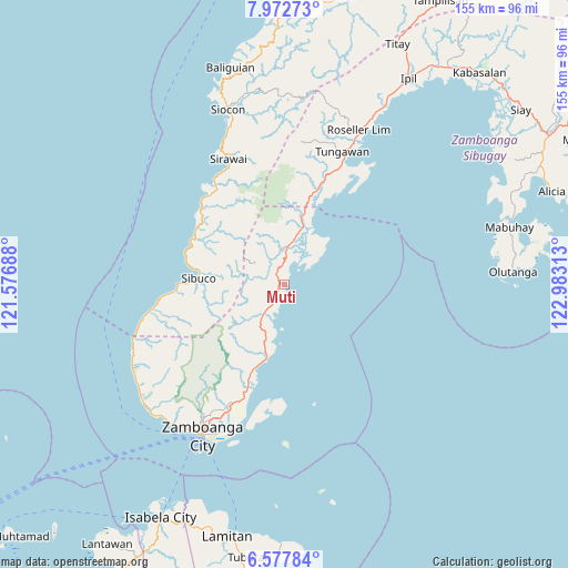
Muti GPS coordinates[2]
7° 16' 32.988" North, 122° 16' 48" East
| Map corner | latitude | longitude |
|---|---|---|
| Upper-left | 7.97273°, | 121.57688° |
| Center: | 7.27583°, | 122.28° |
| Lower-right: | 6.57784°, | 122.98313° |
| Map W x H: | 155.1×155.1 km | = 96.4×96.4mi |
| max Lat: | 20.78733° ⇑88.8% North |
| Muti: | 7.27583° |
| min Lat: | ⇓11.2% South 4.65442° |
| min Long | Muti | max Long |
| 117.04868° | 122.28° | 126.58417° |
| W 42.6%⇐ | ⇒57.4% E |
Elevation
Elevation of Muti is 22 m = 72 ft, and this is 65.9 m = 216 ft below average elevation for this country.
| Max E: |
2262 m = 7421 ft | 51.8% |
| Avg. | 87.9 m = 288 ft | |
| Muti | 22 m = 72 ft | |
Min E: |
-2 m = -7 ft | 48.2% |
See also: Philippines elevation on elevation.city.
Geographical zone
Muti is located in North Torrid zone (between Equator and Tropic of Cancer). Distance of Equator is 809 km =502.7 mi to South.| Distance of | km | miles | from Muti |
|---|---|---|---|
| North Pole | 9198.1 | 5715.4 | to North |
| Arctic Circle | 6592.2 | 4096.2 | to North |
| Tropic Cancer | 1796.9 | 1116.5 | to North |
| Equator | 809 | 502.7 | to South |


Nearby cities:
15 places around Muti: (largest is in red/bold)
• Bolong
20.2 km =12.6 mi,  192°
192°
• Buenavista
5.2 km =3.2 mi,  211°
211°
• Bunguiao
21.2 km =13.2 mi, 205°
• Calabasa
6 km =3.7 mi,  237°
237°
• Curuan
9.4 km =5.8 mi, 213°
• Dulian
20.5 km =12.7 mi, 213°
• Limaong
13.4 km =8.3 mi,  45°
45°
• Mangusu
5.5 km =3.4 mi,  357°
357°
• Quinipot
12.5 km =7.8 mi, 211°
• Sangali
24.5 km =15.2 mi,  200°
200°
• Sibuco
23.7 km =14.7 mi,  274°
274°
• Sibulao
7 km =4.3 mi,  320°
320°
• Tagasilay
3.8 km =2.4 mi, 321°
• Tigbao
17.7 km =11 mi,  17°
17°
• Vitali
10.6 km =6.6 mi,  5°
5°
Sources, notices
• [Note1] Compared only with cities in Philippines existing in our database
• [Src1] Map data: © OpenStreetMap contributors (CC-BY-SA)
• [Src2] Other city data from geonames.org with taken over terms of usage.
• [Src3] Geographical zone / Annual Mean Temperature by Robert A. Rohde @ Wikipedia
