Matungao geodata
Matungao (Northern Mindanao) is a seat of a third-order administrative division; located in Philippines in Asia/Manila (GMT+8) time zone. In our database, there are 4166 cities with bigger population. Compared to other cities in Philippines, 81.4% of cities are located further ↑North; 73.6% of cities are located further ←West and 93.5% of cities have lower elevation than Matungao. Note1
Administrative division(s):
- Level 1: Northern Mindanao
- Level 2: Province of Lanao del Norte
- Level 3: Matungao


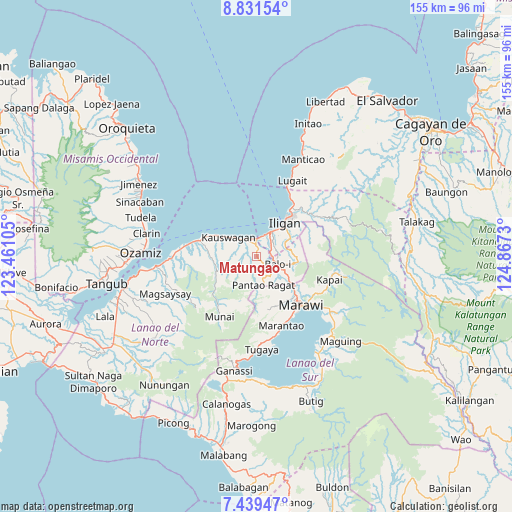
Matungao GPS coordinates[2]
8° 8' 9.996" North, 124° 9' 51.012" East
| Map corner | latitude | longitude |
|---|---|---|
| Upper-left | 8.83154°, | 123.46105° |
| Center: | 8.13611°, | 124.16417° |
| Lower-right: | 7.43947°, | 124.8673° |
| Map W x H: | 154.8×154.8 km | = 96.2×96.2mi |
| max Lat: | 20.78733° ⇑81.4% North |
| Matungao: | 8.13611° |
| min Lat: | ⇓18.6% South 4.65442° |
| min Long | Matungao | max Long |
| 117.04868° | 124.16417° | 126.58417° |
| W 73.6%⇐ | ⇒26.4% E |
Elevation
Elevation of Matungao is 350 m = 1148 ft, and this is 262.1 m = 860 ft above average elevation for this country.
| Max E: |
2262 m = 7421 ft | 6.5% |
| Matungao | 350 m 1148 ft | |
| Avg. | 87.9 m = 288 ft | |
Min E: |
-2 m = -7 ft | 93.5% |
See also: Philippines elevation on elevation.city.
Geographical zone
Matungao is located in North Torrid zone (between Equator and Tropic of Cancer). Distance of Equator is 904.7 km =562.2 mi to South.| Distance of | km | miles | from Matungao |
|---|---|---|---|
| North Pole | 9102.4 | 5656 | to North |
| Arctic Circle | 6496.5 | 4036.7 | to North |
| Tropic Cancer | 1701.3 | 1057.1 | to North |
| Equator | 904.7 | 562.2 | to South |


Nearby cities:
15 places around Matungao: (largest is in red/bold)
• Boroon
5.4 km =3.4 mi,  15°
15°
• Dimayon
7.9 km =4.9 mi,  191°
191°
• Iligan
13.5 km =8.4 mi,  40°
40°
• Kalanganan
10.8 km =6.7 mi,  122°
122°
• Kauswagan
10.7 km =6.6 mi,  305°
305°
• Kawit
12.2 km =7.6 mi,  298°
298°
• Linamon
5.6 km =3.5 mi,  358°
358°
• Mamungan
6.3 km =3.9 mi,  109°
109°
• Mantampay
6.7 km =4.2 mi,  59°
59°
• Maria Cristina
5.5 km =3.4 mi,  52°
52°
• Nañgka
4 km =2.5 mi,  31°
31°
• Pantao-Ragat
6.8 km =4.2 mi,  210°
210°
• Pantar
13 km =8.1 mi,  126°
126°
• Poona-Piagapo
7.9 km =4.9 mi,  221°
221°
• Tacub
8.4 km =5.2 mi, 312°
Sources, notices
• [Note1] Compared only with cities in Philippines existing in our database
• [Src1] Map data: © OpenStreetMap contributors (CC-BY-SA)
• [Src2] Other city data from geonames.org with taken over terms of usage.
• [Src3] Geographical zone / Annual Mean Temperature by Robert A. Rohde @ Wikipedia
