Minien East geodata
Minien East (Ilocos) is a populated place; located in Philippines in Asia/Manila (GMT+8) time zone. With population of 6,111 people, there are 1026 cities with bigger population in this country. Compared to other cities in Philippines, 87.1% of cities are located further ↓South; 91.3% of cities are located further →East and 56.1% of cities have higher elevation than Minien East. Note1


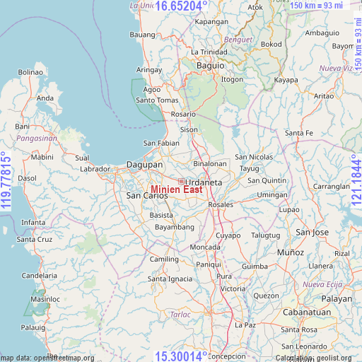
Minien East GPS coordinates[2]
15° 58' 38.028" North, 120° 28' 52.572" East
| Map corner | latitude | longitude |
|---|---|---|
| Upper-left | 16.65204°, | 119.77815° |
| Center: | 15.97723°, | 120.48127° |
| Lower-right: | 15.30014°, | 121.1844° |
| Map W x H: | 150.3×150.3 km | = 93.4×93.4mi |
| max Lat: | 20.78733° ⇑12.9% North |
| Minien East: | 15.97723° |
| min Lat: | ⇓87.1% South 4.65442° |
| min Long | Minien East | max Long |
| 117.04868° | 120.48127° | 126.58417° |
| W 8.7%⇐ | ⇒91.3% E |
Elevation
Elevation of Minien East is 19 m = 62 ft, and this is 68.9 m = 226 ft below average elevation for this country.
| Max E: |
2262 m = 7421 ft | 56.1% |
| Avg. | 87.9 m = 288 ft | |
| Minien East | 19 m = 62 ft | |
Min E: |
-2 m = -7 ft | 43.9% |
See also: Philippines elevation on elevation.city.
Geographical zone
Minien East is located in North Torrid zone (between Equator and Tropic of Cancer). Distance of this Northern Tropic circle is 829.4 km =515.4 mi to North.| Distance of | km | miles | from Minien East |
|---|---|---|---|
| North Pole | 8230.6 | 5114.3 | to North |
| Arctic Circle | 5624.7 | 3495 | to North |
| Tropic Cancer | 829.4 | 515.4 | to North |
| Equator | 1776.5 | 1103.9 | to South |


Nearby cities:
15 places around Minien East: (largest is in red/bold)
• Bacundao Weste
6.9 km =4.3 mi,  184°
184°
• Balingueo
7.9 km =4.9 mi,  254°
254°
• Bolaoit
7.4 km =4.6 mi,  227°
227°
• Canan Norte
7.5 km =4.7 mi, 182°
• Catablan
1.5 km =0.9 mi,  96°
96°
• Loqueb Este
5.2 km =3.2 mi, 226°
• Lunec
2.7 km =1.7 mi,  161°
161°
• Malanay
8.4 km =5.2 mi,  294°
294°
• Manaoag
7.4 km =4.6 mi,  3°
3°
• Mapandan
6 km =3.7 mi,  331°
331°
• Maticmatic
3.3 km =2.1 mi, 287°
• Nilombot
7.6 km =4.7 mi,  321°
321°
• Patayac
6.5 km =4 mi,  255°
255°
• Talospatang
7.9 km =4.9 mi,  212°
212°
• Tebag East
1.5 km =0.9 mi, 286°
Sources, notices
• [Note1] Compared only with cities in Philippines existing in our database
• [Src1] Map data: © OpenStreetMap contributors (CC-BY-SA)
• [Src2] Other city data from geonames.org with taken over terms of usage.
• [Src3] Geographical zone / Annual Mean Temperature by Robert A. Rohde @ Wikipedia
