Bacundao Weste geodata
Bacundao Weste (Ilocos) is a populated place; located in Philippines in Asia/Manila (GMT+8) time zone. With population of 2,323 people, there are 3624 cities with bigger population in this country. Compared to other cities in Philippines, 86.3% of cities are located further ↓South; 91.4% of cities are located further →East and 63.6% of cities have lower elevation than Bacundao Weste. Note1


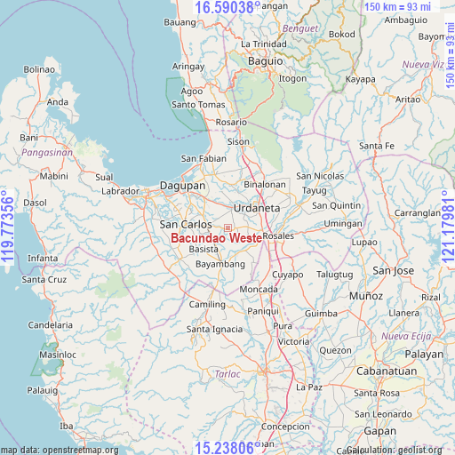
Bacundao Weste GPS coordinates[2]
15° 54' 55.296" North, 120° 28' 36.048" East
| Map corner | latitude | longitude |
|---|---|---|
| Upper-left | 16.59038°, | 119.77356° |
| Center: | 15.91536°, | 120.47668° |
| Lower-right: | 15.23806°, | 121.17981° |
| Map W x H: | 150.4×150.4 km | = 93.5×93.5mi |
| max Lat: | 20.78733° ⇑13.7% North |
| Bacundao Weste: | 15.91536° |
| min Lat: | ⇓86.3% South 4.65442° |
| min Long | Bacundao Weste | max Long |
| 117.04868° | 120.47668° | 126.58417° |
| W 8.6%⇐ | ⇒91.4% E |
Elevation
Elevation of Bacundao Weste is 39 m = 128 ft, and this is 48.9 m = 160 ft below average elevation for this country.
| Max E: |
2262 m = 7421 ft | 36.4% |
| Avg. | 87.9 m = 288 ft | |
| Bacundao Weste | 39 m = 128 ft | |
Min E: |
-2 m = -7 ft | 63.6% |
See also: Philippines elevation on elevation.city.
Geographical zone
Bacundao Weste is located in North Torrid zone (between Equator and Tropic of Cancer). Distance of this Northern Tropic circle is 836.3 km =519.7 mi to North.| Distance of | km | miles | from Bacundao Weste |
|---|---|---|---|
| North Pole | 8237.4 | 5118.5 | to North |
| Arctic Circle | 5631.6 | 3499.3 | to North |
| Tropic Cancer | 836.3 | 519.7 | to North |
| Equator | 1769.6 | 1099.6 | to South |


Nearby cities:
15 places around Bacundao Weste: (largest is in red/bold)
• Bolaoit
5.3 km =3.3 mi,  290°
290°
• Botao
6.4 km =4 mi,  271°
271°
• Canan Norte
0.6 km =0.4 mi,  170°
170°
• Capulaan
6.6 km =4.1 mi,  100°
100°
• Catablan
7 km =4.3 mi,  16°
16°
• Don Pedro
6 km =3.7 mi,  235°
235°
• Lepa
4.4 km =2.7 mi,  218°
218°
• Loqueb Este
4.6 km =2.9 mi,  315°
315°
• Lunec
4.5 km =2.8 mi, 17°
• Malasiqui
6.7 km =4.2 mi, 274°
• Minien East
6.9 km =4.3 mi,  4°
4°
• Olea
6.2 km =3.9 mi,  162°
162°
• Polong Norte
6.1 km =3.8 mi,  256°
256°
• Talospatang
3.8 km =2.4 mi, 272°
• Unzad
6.7 km =4.2 mi,  86°
86°
Sources, notices
• [Note1] Compared only with cities in Philippines existing in our database
• [Src1] Map data: © OpenStreetMap contributors (CC-BY-SA)
• [Src2] Other city data from geonames.org with taken over terms of usage.
• [Src3] Geographical zone / Annual Mean Temperature by Robert A. Rohde @ Wikipedia
