Mapulo geodata
Mapulo (Calabarzon) is a populated place; located in Philippines in Asia/Manila (GMT+8) time zone. With population of 2,828 people, there are 2745 cities with bigger population in this country. Compared to other cities in Philippines, 64.7% of cities are located further ↓South; 71.9% of cities are located further →East and 90.8% of cities have lower elevation than Mapulo. Note1


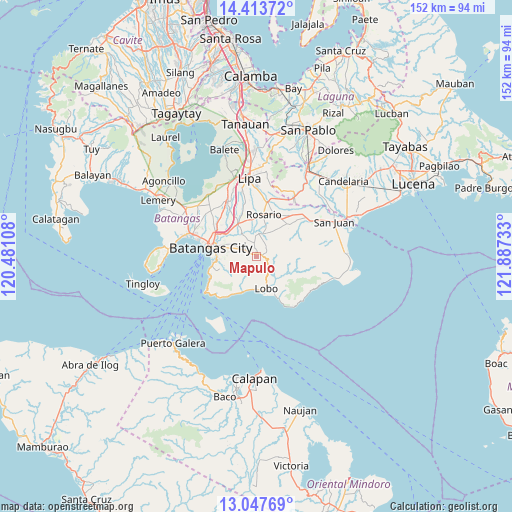
Mapulo GPS coordinates[2]
13° 43' 54.12" North, 121° 11' 3.12" East
| Map corner | latitude | longitude |
|---|---|---|
| Upper-left | 14.41372°, | 120.48108° |
| Center: | 13.7317°, | 121.1842° |
| Lower-right: | 13.04769°, | 121.88733° |
| Map W x H: | 151.9×151.9 km | = 94.4×94.4mi |
| max Lat: | 20.78733° ⇑35.3% North |
| Mapulo: | 13.7317° |
| min Lat: | ⇓64.7% South 4.65442° |
| min Long | Mapulo | max Long |
| 117.04868° | 121.1842° | 126.58417° |
| W 28.1%⇐ | ⇒71.9% E |
Elevation
Elevation of Mapulo is 243 m = 797 ft, and this is 155.1 m = 509 ft above average elevation for this country.
| Max E: |
2262 m = 7421 ft | 9.2% |
| Mapulo | 243 m 797 ft | |
| Avg. | 87.9 m = 288 ft | |
Min E: |
-2 m = -7 ft | 90.8% |
See also: Philippines elevation on elevation.city.
Geographical zone
Mapulo is located in North Torrid zone (between Equator and Tropic of Cancer). Distance of this Northern Tropic circle is 1079.1 km =670.5 mi to North.| Distance of | km | miles | from Mapulo |
|---|---|---|---|
| North Pole | 8480.2 | 5269.4 | to North |
| Arctic Circle | 5874.4 | 3650.2 | to North |
| Tropic Cancer | 1079.1 | 670.5 | to North |
| Equator | 1526.8 | 948.7 | to South |


Nearby cities:
15 places around Mapulo: (largest is in red/bold)
• Banalo
9.5 km =5.9 mi,  181°
181°
• Banaybanay
13.3 km =8.3 mi,  7°
7°
• Bulihan
11.1 km =6.9 mi,  38°
38°
• Dagatan
1.8 km =1.1 mi,  63°
63°
• Haligue
10.3 km =6.4 mi,  225°
225°
• Ibaan
11 km =6.8 mi,  329°
329°
• Lapolapo
12.4 km =7.7 mi,  336°
336°
• Lobo
9.7 km =6 mi,  162°
162°
• Matala
11.2 km =7 mi, 343°
• Rosario
12.8 km =8 mi, 9°
• San Isidro
6.5 km =4 mi,  50°
50°
• Santo Niño
10.2 km =6.3 mi,  250°
250°
• Talahib Payap
9.4 km =5.8 mi,  213°
213°
• Talaibon
12.7 km =7.9 mi, 337°
• Taysan
7.4 km =4.6 mi,  4°
4°
Sources, notices
• [Note1] Compared only with cities in Philippines existing in our database
• [Src1] Map data: © OpenStreetMap contributors (CC-BY-SA)
• [Src2] Other city data from geonames.org with taken over terms of usage.
• [Src3] Geographical zone / Annual Mean Temperature by Robert A. Rohde @ Wikipedia
