Ibaan geodata
Ibaan (Calabarzon) is a seat of a third-order administrative division; located in Philippines in Asia/Manila (GMT+8) time zone. With population of 9,430 people, there are 654 cities with bigger population in this country. Compared to other cities in Philippines, 65.7% of cities are located further ↓South; 72.9% of cities are located further →East and 83.6% of cities have lower elevation than Ibaan. Note1


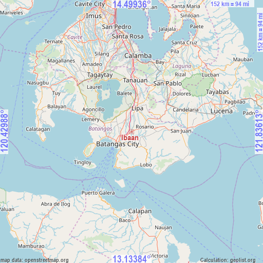
Ibaan GPS coordinates[2]
13° 49' 3.36" North, 121° 7' 58.8" East
| Map corner | latitude | longitude |
|---|---|---|
| Upper-left | 14.49936°, | 120.42988° |
| Center: | 13.8176°, | 121.133° |
| Lower-right: | 13.13384°, | 121.83613° |
| Map W x H: | 151.8×151.8 km | = 94.3×94.3mi |
| max Lat: | 20.78733° ⇑34.3% North |
| Ibaan: | 13.8176° |
| min Lat: | ⇓65.7% South 4.65442° |
| min Long | Ibaan | max Long |
| 117.04868° | 121.133° | 126.58417° |
| W 27.1%⇐ | ⇒72.9% E |
Elevation
Elevation of Ibaan is 122 m = 400 ft, and this is 34.1 m = 112 ft above average elevation for this country.
| Max E: |
2262 m = 7421 ft | 16.4% |
| Ibaan | 122 m 400 ft | |
| Avg. | 87.9 m = 288 ft | |
Min E: |
-2 m = -7 ft | 83.6% |
See also: Philippines elevation on elevation.city.
Geographical zone
Ibaan is located in North Torrid zone (between Equator and Tropic of Cancer). Distance of this Northern Tropic circle is 1069.5 km =664.6 mi to North.| Distance of | km | miles | from Ibaan |
|---|---|---|---|
| North Pole | 8470.7 | 5263.4 | to North |
| Arctic Circle | 5864.8 | 3644.2 | to North |
| Tropic Cancer | 1069.5 | 664.6 | to North |
| Equator | 1536.4 | 954.7 | to South |


Nearby cities:
15 places around Ibaan: (largest is in red/bold)
• Aya
8.8 km =5.5 mi,  346°
346°
• Banaybanay
8.1 km =5 mi,  63°
63°
• Batangas
10.5 km =6.5 mi,  229°
229°
• Bukal
4.7 km =2.9 mi,  296°
296°
• Lapolapo
1.9 km =1.2 mi,  16°
16°
• Matala
2.7 km =1.7 mi, 62°
• Rizal
7.1 km =4.4 mi, 23°
• Rosario
8.3 km =5.2 mi,  68°
68°
• San Jose
7.4 km =4.6 mi,  335°
335°
• San Miguel
9.4 km =5.8 mi,  48°
48°
• Santa Cruz
8 km =5 mi, 48°
• Santo Niño
3.5 km =2.2 mi,  359°
359°
• Talaibon
2.4 km =1.5 mi, 18°
• Taysan
6.5 km =4 mi,  109°
109°
• Taysan
7 km =4.3 mi,  326°
326°
Sources, notices
• [Note1] Compared only with cities in Philippines existing in our database
• [Src1] Map data: © OpenStreetMap contributors (CC-BY-SA)
• [Src2] Other city data from geonames.org with taken over terms of usage.
• [Src3] Geographical zone / Annual Mean Temperature by Robert A. Rohde @ Wikipedia
