Manga geodata
Manga (Cagayan Valley) is a populated place; located in Philippines in Asia/Manila (GMT+8) time zone. With population of 2,211 people, there are 3867 cities with bigger population in this country. Compared to other cities in Philippines, 97.2% of cities are located further ↓South; 61.9% of cities are located further →East and 76.2% of cities have lower elevation than Manga. Note1
Administrative division(s):
- Level 1: Cagayan Valley
- Level 2: Province of Cagayan
- Level 3: Peñablanca


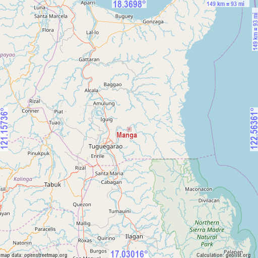
Manga GPS coordinates[2]
17° 42' 4.428" North, 121° 51' 37.728" East
| Map corner | latitude | longitude |
|---|---|---|
| Upper-left | 18.3698°, | 121.15736° |
| Center: | 17.70123°, | 121.86048° |
| Lower-right: | 17.03016°, | 122.56361° |
| Map W x H: | 149×149 km | = 92.6×92.6mi |
| max Lat: | 20.78733° ⇑2.8% North |
| Manga: | 17.70123° |
| min Lat: | ⇓97.2% South 4.65442° |
| min Long | Manga | max Long |
| 117.04868° | 121.86048° | 126.58417° |
| W 38.1%⇐ | ⇒61.9% E |
Elevation
Elevation of Manga is 73 m = 240 ft, and this is 14.9 m = 49 ft below average elevation for this country.
| Max E: |
2262 m = 7421 ft | 23.8% |
| Avg. | 87.9 m = 288 ft | |
| Manga | 73 m = 240 ft | |
Min E: |
-2 m = -7 ft | 76.2% |
See also: Philippines elevation on elevation.city.
Geographical zone
Manga is located in North Torrid zone (between Equator and Tropic of Cancer). Distance of this Northern Tropic circle is 637.7 km =396.2 mi to North.| Distance of | km | miles | from Manga |
|---|---|---|---|
| North Pole | 8038.9 | 4995.1 | to North |
| Arctic Circle | 5433 | 3375.9 | to North |
| Tropic Cancer | 637.7 | 396.2 | to North |
| Equator | 1968.2 | 1223 | to South |


Nearby cities:
15 places around Manga: (largest is in red/bold)
• Aggugaddah
6.1 km =3.8 mi,  268°
268°
• Atulayan
18.1 km =11.2 mi,  257°
257°
• Carig
13.2 km =8.2 mi,  249°
249°
• Dassun
16.5 km =10.3 mi,  287°
287°
• Dodan
9.7 km =6 mi,  226°
226°
• Gammad
12.4 km =7.7 mi, 274°
• Iguig
14.2 km =8.8 mi, 292°
• Lanna
17 km =10.6 mi, 268°
• Lapi
4.3 km =2.7 mi,  67°
67°
• Larion Alto
13.2 km =8.2 mi, 233°
• Minanga Norte
15.4 km =9.6 mi,  295°
295°
• Nattapian
16.9 km =10.5 mi, 260°
• Peñablanca
11.3 km =7 mi, 228°
• Quibal
5.5 km =3.4 mi, 287°
• Tuguegarao
17.4 km =10.8 mi,  236°
236°
Sources, notices
• [Note1] Compared only with cities in Philippines existing in our database
• [Src1] Map data: © OpenStreetMap contributors (CC-BY-SA)
• [Src2] Other city data from geonames.org with taken over terms of usage.
• [Src3] Geographical zone / Annual Mean Temperature by Robert A. Rohde @ Wikipedia
