Quibal geodata
Quibal (Cagayan Valley) is a populated place; located in Philippines in Asia/Manila (GMT+8) time zone. With population of 2,376 people, there are 3506 cities with bigger population in this country. Compared to other cities in Philippines, 97.4% of cities are located further ↓South; 62.5% of cities are located further →East and 74.9% of cities have lower elevation than Quibal. Note1
Administrative division(s):
- Level 1: Cagayan Valley
- Level 2: Province of Cagayan
- Level 3: Peñablanca


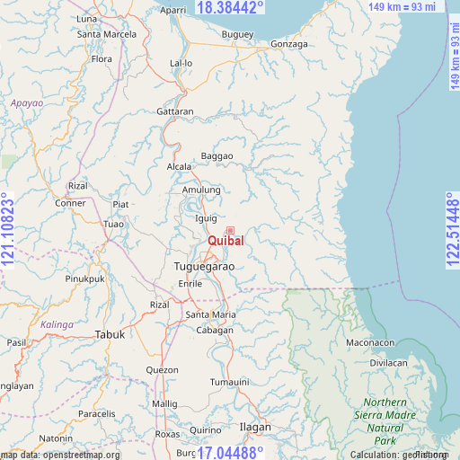
Quibal GPS coordinates[2]
17° 42' 57.24" North, 121° 48' 40.86" East
| Map corner | latitude | longitude |
|---|---|---|
| Upper-left | 18.38442°, | 121.10823° |
| Center: | 17.7159°, | 121.81135° |
| Lower-right: | 17.04488°, | 122.51448° |
| Map W x H: | 148.9×148.9 km | = 92.5×92.5mi |
| max Lat: | 20.78733° ⇑2.6% North |
| Quibal: | 17.7159° |
| min Lat: | ⇓97.4% South 4.65442° |
| min Long | Quibal | max Long |
| 117.04868° | 121.81135° | 126.58417° |
| W 37.5%⇐ | ⇒62.5% E |
Elevation
Elevation of Quibal is 68 m = 223 ft, and this is 19.9 m = 65 ft below average elevation for this country.
| Max E: |
2262 m = 7421 ft | 25.1% |
| Avg. | 87.9 m = 288 ft | |
| Quibal | 68 m = 223 ft | |
Min E: |
-2 m = -7 ft | 74.9% |
See also: Philippines elevation on elevation.city.
Geographical zone
Quibal is located in North Torrid zone (between Equator and Tropic of Cancer). Distance of this Northern Tropic circle is 636.1 km =395.3 mi to North.| Distance of | km | miles | from Quibal |
|---|---|---|---|
| North Pole | 8037.2 | 4994.1 | to North |
| Arctic Circle | 5431.4 | 3374.9 | to North |
| Tropic Cancer | 636.1 | 395.3 | to North |
| Equator | 1969.8 | 1224 | to South |


Nearby cities:
15 places around Quibal: (largest is in red/bold)
• Aggugaddah
2 km =1.2 mi,  208°
208°
• Atulayan
13.7 km =8.5 mi,  245°
245°
• Carig
9.5 km =5.9 mi,  228°
228°
• Dassun
11.1 km =6.9 mi,  287°
287°
• Dodan
8.5 km =5.3 mi,  192°
192°
• Estefania
13.2 km =8.2 mi,  314°
314°
• Gammad
7.2 km =4.5 mi,  265°
265°
• Iguig
8.8 km =5.5 mi,  295°
295°
• Lanna
12 km =7.5 mi,  259°
259°
• Lapi
9.2 km =5.7 mi,  89°
89°
• Larion Alto
10.9 km =6.8 mi, 209°
• Manga
5.5 km =3.4 mi,  107°
107°
• Minanga Norte
10 km =6.2 mi, 299°
• Nattapian
12.3 km =7.6 mi, 248°
• Peñablanca
9.7 km =6 mi,  199°
199°
Sources, notices
• [Note1] Compared only with cities in Philippines existing in our database
• [Src1] Map data: © OpenStreetMap contributors (CC-BY-SA)
• [Src2] Other city data from geonames.org with taken over terms of usage.
• [Src3] Geographical zone / Annual Mean Temperature by Robert A. Rohde @ Wikipedia
