Malamote geodata
Malamote (Soccsksargen) is a populated place; located in Philippines in Asia/Manila (GMT+8) time zone. With population of 3,098 people, there are 2418 cities with bigger population in this country. Compared to other cities in Philippines, 91% of cities are located further ↑North; 86.7% of cities are located further ←West and 76.2% of cities have lower elevation than Malamote. Note1


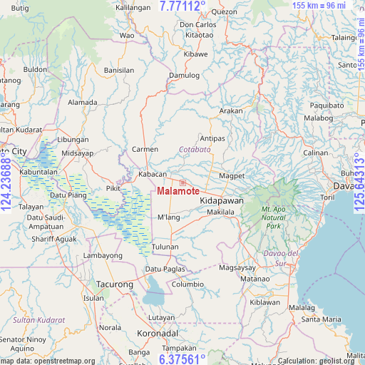
Malamote GPS coordinates[2]
7° 4' 26.004" North, 124° 56' 24" East
| Map corner | latitude | longitude |
|---|---|---|
| Upper-left | 7.77112°, | 124.23688° |
| Center: | 7.07389°, | 124.94° |
| Lower-right: | 6.37561°, | 125.64313° |
| Map W x H: | 155.2×155.2 km | = 96.4×96.4mi |
| max Lat: | 20.78733° ⇑91% North |
| Malamote: | 7.07389° |
| min Lat: | ⇓9% South 4.65442° |
| min Long | Malamote | max Long |
| 117.04868° | 124.94° | 126.58417° |
| W 86.7%⇐ | ⇒13.3% E |
Elevation
Elevation of Malamote is 73 m = 240 ft, and this is 14.9 m = 49 ft below average elevation for this country.
| Max E: |
2262 m = 7421 ft | 23.8% |
| Avg. | 87.9 m = 288 ft | |
| Malamote | 73 m = 240 ft | |
Min E: |
-2 m = -7 ft | 76.2% |
See also: Philippines elevation on elevation.city.
Geographical zone
Malamote is located in North Torrid zone (between Equator and Tropic of Cancer). Distance of Equator is 786.5 km =488.7 mi to South.| Distance of | km | miles | from Malamote |
|---|---|---|---|
| North Pole | 9220.5 | 5729.4 | to North |
| Arctic Circle | 6614.6 | 4110.1 | to North |
| Tropic Cancer | 1819.4 | 1130.5 | to North |
| Equator | 786.5 | 488.7 | to South |


Nearby cities:
15 places around Malamote: (largest is in red/bold)
• Amas
5.2 km =3.2 mi,  111°
111°
• Banawa
12 km =7.5 mi,  317°
317°
• Batasan
12.9 km =8 mi, 110°
• Bialong
11.8 km =7.3 mi,  208°
208°
• Dunguan
16.3 km =10.1 mi, 212°
• Kabacan
12.8 km =8 mi,  286°
286°
• Kalaisan
13.6 km =8.5 mi,  121°
121°
• Labu-o
12.4 km =7.7 mi,  68°
68°
• Linao
10.9 km =6.8 mi,  16°
16°
• Malapag
15.1 km =9.4 mi,  295°
295°
• Marbel
5.6 km =3.5 mi,  326°
326°
• Matalam
4.6 km =2.9 mi, 287°
• New Cebu
10.6 km =6.6 mi,  77°
77°
• Paatan
5.4 km =3.4 mi,  340°
340°
• President Roxas
15.6 km =9.7 mi,  54°
54°
Sources, notices
• [Note1] Compared only with cities in Philippines existing in our database
• [Src1] Map data: © OpenStreetMap contributors (CC-BY-SA)
• [Src2] Other city data from geonames.org with taken over terms of usage.
• [Src3] Geographical zone / Annual Mean Temperature by Robert A. Rohde @ Wikipedia
