President Roxas geodata
President Roxas (Soccsksargen) is a populated place; located in Philippines in Asia/Manila (GMT+8) time zone. With population of 10,879 people, there are 571 cities with bigger population in this country. Compared to other cities in Philippines, 90% of cities are located further ↑North; 88.8% of cities are located further ←West and 84% of cities have lower elevation than President Roxas. Note1
Administrative division(s):
- Level 1: Soccsksargen
- Level 2: Province of Cotabato
- Level 3: President Roxas


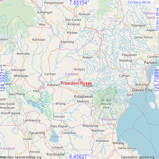
President Roxas GPS coordinates[2]
7° 9' 15.984" North, 125° 3' 20.988" East
| Map corner | latitude | longitude |
|---|---|---|
| Upper-left | 7.85154°, | 124.35271° |
| Center: | 7.15444°, | 125.05583° |
| Lower-right: | 6.45627°, | 125.75896° |
| Map W x H: | 155.1×155.1 km | = 96.4×96.4mi |
| max Lat: | 20.78733° ⇑90% North |
| President Roxas: | 7.15444° |
| min Lat: | ⇓10% South 4.65442° |
| min Long | President Roxas | max Long |
| 117.04868° | 125.05583° | 126.58417° |
| W 88.8%⇐ | ⇒11.2% E |
Elevation
Elevation of President Roxas is 125 m = 410 ft, and this is 37.1 m = 122 ft above average elevation for this country.
| Max E: |
2262 m = 7421 ft | 16% |
| President Roxas | 125 m 410 ft | |
| Avg. | 87.9 m = 288 ft | |
Min E: |
-2 m = -7 ft | 84% |
See also: Philippines elevation on elevation.city.
Geographical zone
President Roxas is located in North Torrid zone (between Equator and Tropic of Cancer). Distance of Equator is 795.5 km =494.3 mi to South.| Distance of | km | miles | from President Roxas |
|---|---|---|---|
| North Pole | 9211.6 | 5723.8 | to North |
| Arctic Circle | 6605.7 | 4104.6 | to North |
| Tropic Cancer | 1810.4 | 1124.9 | to North |
| Equator | 795.5 | 494.3 | to South |


Nearby cities:
15 places around President Roxas: (largest is in red/bold)
• Amas
13.4 km =8.3 mi,  216°
216°
• Banawa
20.9 km =13 mi,  269°
269°
• Batasan
13.5 km =8.4 mi,  182°
182°
• Kalaisan
16.1 km =10 mi, 184°
• Kidapawan
16.7 km =10.4 mi,  167°
167°
• Labu-o
4.6 km =2.9 mi,  194°
194°
• Linao
9.9 km =6.2 mi,  278°
278°
• Magpet
8.9 km =5.5 mi,  132°
132°
• Makilala
23 km =14.3 mi, 168°
• Malamote
15.6 km =9.7 mi,  234°
234°
• Marbel
16.4 km =10.2 mi,  254°
254°
• Matalam
18.7 km =11.6 mi, 246°
• New Cebu
7 km =4.3 mi,  200°
200°
• Paatan
15.1 km =9.4 mi,  255°
255°
• Saguing
19.5 km =12.1 mi, 172°
Sources, notices
• [Note1] Compared only with cities in Philippines existing in our database
• [Src1] Map data: © OpenStreetMap contributors (CC-BY-SA)
• [Src2] Other city data from geonames.org with taken over terms of usage.
• [Src3] Geographical zone / Annual Mean Temperature by Robert A. Rohde @ Wikipedia
