Kabacan geodata
Kabacan (Soccsksargen) is a seat of a third-order administrative division; located in Philippines in Asia/Manila (GMT+8) time zone. With population of 31,769 people, there are 263 cities with bigger population in this country. Compared to other cities in Philippines, 90.6% of cities are located further ↑North; 85% of cities are located further ←West and 51.1% of cities have lower elevation than Kabacan. Note1


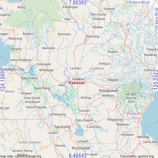
Kabacan GPS coordinates[2]
7° 6' 24.012" North, 124° 49' 45.012" East
| Map corner | latitude | longitude |
|---|---|---|
| Upper-left | 7.80385°, | 124.12605° |
| Center: | 7.10667°, | 124.82917° |
| Lower-right: | 6.40843°, | 125.5323° |
| Map W x H: | 155.2×155.2 km | = 96.4×96.4mi |
| max Lat: | 20.78733° ⇑90.6% North |
| Kabacan: | 7.10667° |
| min Lat: | ⇓9.4% South 4.65442° |
| min Long | Kabacan | max Long |
| 117.04868° | 124.82917° | 126.58417° |
| W 85%⇐ | ⇒15% E |
Elevation
Elevation of Kabacan is 24 m = 79 ft, and this is 63.9 m = 210 ft below average elevation for this country.
| Max E: |
2262 m = 7421 ft | 48.9% |
| Avg. | 87.9 m = 288 ft | |
| Kabacan | 24 m = 79 ft | |
Min E: |
-2 m = -7 ft | 51.1% |
See also: Philippines elevation on elevation.city.
Geographical zone
Kabacan is located in North Torrid zone (between Equator and Tropic of Cancer). Distance of Equator is 790.2 km =491 mi to South.| Distance of | km | miles | from Kabacan |
|---|---|---|---|
| North Pole | 9216.9 | 5727.1 | to North |
| Arctic Circle | 6611 | 4107.9 | to North |
| Tropic Cancer | 1815.7 | 1128.2 | to North |
| Equator | 790.2 | 491 | to South |


Nearby cities:
15 places around Kabacan: (largest is in red/bold)
• Banawa
6.7 km =4.2 mi,  38°
38°
• Bialong
15.5 km =9.6 mi,  154°
154°
• Bulit
4.5 km =2.8 mi,  282°
282°
• Carmen
11.6 km =7.2 mi,  339°
339°
• Layog
11.4 km =7.1 mi,  252°
252°
• Limbalod
4.4 km =2.7 mi,  310°
310°
• Malamote
12.8 km =8 mi,  106°
106°
• Malapag
3.3 km =2.1 mi, 335°
• Marbel
9.3 km =5.8 mi,  83°
83°
• Matalam
8.2 km =5.1 mi, 105°
• Nunguan
15.6 km =9.7 mi, 278°
• Paatan
10.6 km =6.6 mi, 82°
• Pagalungan
15.2 km =9.4 mi, 248°
• Pedtad
6.2 km =3.9 mi, 344°
• Tungol
8.9 km =5.5 mi, 251°
Sources, notices
• [Note1] Compared only with cities in Philippines existing in our database
• [Src1] Map data: © OpenStreetMap contributors (CC-BY-SA)
• [Src2] Other city data from geonames.org with taken over terms of usage.
• [Src3] Geographical zone / Annual Mean Temperature by Robert A. Rohde @ Wikipedia
