Paatan geodata
Paatan (Soccsksargen) is a populated place; located in Philippines in Asia/Manila (GMT+8) time zone. With population of 4,526 people, there are 1479 cities with bigger population in this country. Compared to other cities in Philippines, 90.4% of cities are located further ↑North; 86.5% of cities are located further ←West and 70.8% of cities have lower elevation than Paatan. Note1


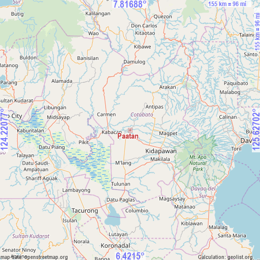
Paatan GPS coordinates[2]
7° 7' 10.992" North, 124° 55' 26.004" East
| Map corner | latitude | longitude |
|---|---|---|
| Upper-left | 7.81688°, | 124.22077° |
| Center: | 7.11972°, | 124.92389° |
| Lower-right: | 6.4215°, | 125.62702° |
| Map W x H: | 155.2×155.2 km | = 96.4×96.4mi |
| max Lat: | 20.78733° ⇑90.4% North |
| Paatan: | 7.11972° |
| min Lat: | ⇓9.6% South 4.65442° |
| min Long | Paatan | max Long |
| 117.04868° | 124.92389° | 126.58417° |
| W 86.5%⇐ | ⇒13.5% E |
Elevation
Elevation of Paatan is 54 m = 177 ft, and this is 33.9 m = 111 ft below average elevation for this country.
| Max E: |
2262 m = 7421 ft | 29.2% |
| Avg. | 87.9 m = 288 ft | |
| Paatan | 54 m = 177 ft | |
Min E: |
-2 m = -7 ft | 70.8% |
See also: Philippines elevation on elevation.city.
Geographical zone
Paatan is located in North Torrid zone (between Equator and Tropic of Cancer). Distance of Equator is 791.6 km =491.9 mi to South.| Distance of | km | miles | from Paatan |
|---|---|---|---|
| North Pole | 9215.4 | 5726.2 | to North |
| Arctic Circle | 6609.5 | 4107 | to North |
| Tropic Cancer | 1814.3 | 1127.4 | to North |
| Equator | 791.6 | 491.9 | to South |


Nearby cities:
15 places around Paatan: (largest is in red/bold)
• Amas
9.6 km =6 mi,  136°
136°
• Banawa
7.4 km =4.6 mi,  300°
300°
• Bialong
15.9 km =9.9 mi,  194°
194°
• Bulit
14.8 km =9.2 mi,  268°
268°
• Kabacan
10.6 km =6.6 mi,  262°
262°
• Labu-o
13.4 km =8.3 mi,  92°
92°
• Limbalod
13.9 km =8.6 mi,  276°
276°
• Linao
7.2 km =4.5 mi,  41°
41°
• Malamote
5.4 km =3.4 mi,  160°
160°
• Malapag
11.9 km =7.4 mi, 277°
• Marbel
1.3 km =0.8 mi,  251°
251°
• Matalam
4.5 km =2.8 mi,  214°
214°
• New Cebu
12.4 km =7.7 mi,  102°
102°
• Pedtad
12.9 km =8 mi,  290°
290°
• President Roxas
15.1 km =9.4 mi,  75°
75°
Sources, notices
• [Note1] Compared only with cities in Philippines existing in our database
• [Src1] Map data: © OpenStreetMap contributors (CC-BY-SA)
• [Src2] Other city data from geonames.org with taken over terms of usage.
• [Src3] Geographical zone / Annual Mean Temperature by Robert A. Rohde @ Wikipedia
