Lintangan geodata
Lintangan (Zamboanga Peninsula) is a populated place; located in Philippines in Asia/Manila (GMT+8) time zone. With population of 3,211 people, there are 2293 cities with bigger population in this country. Compared to other cities in Philippines, 89.3% of cities are located further ↑North; 60.8% of cities are located further →East and 70.2% of cities have higher elevation than Lintangan. Note1
Administrative division(s):
- Level 1: Zamboanga Peninsula
- Level 2: Province of Zamboanga del Norte
- Level 3: Sibuco


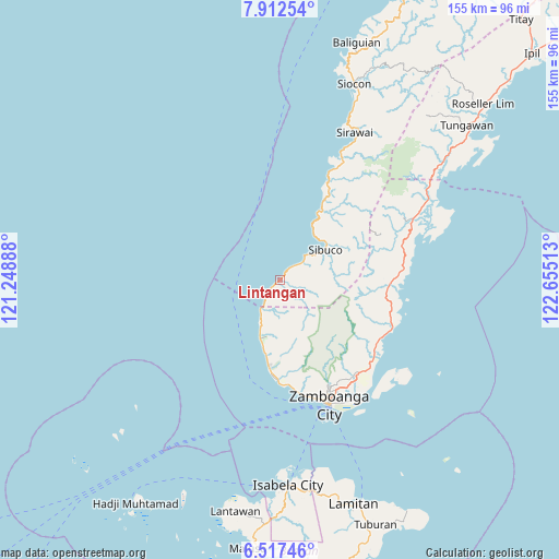
Lintangan GPS coordinates[2]
7° 12' 55.944" North, 121° 57' 7.2" East
| Map corner | latitude | longitude |
|---|---|---|
| Upper-left | 7.91254°, | 121.24888° |
| Center: | 7.21554°, | 121.952° |
| Lower-right: | 6.51746°, | 122.65513° |
| Map W x H: | 155.1×155.1 km | = 96.4×96.4mi |
| max Lat: | 20.78733° ⇑89.3% North |
| Lintangan: | 7.21554° |
| min Lat: | ⇓10.7% South 4.65442° |
| min Long | Lintangan | max Long |
| 117.04868° | 121.952° | 126.58417° |
| W 39.2%⇐ | ⇒60.8% E |
Elevation
Elevation of Lintangan is 12 m = 39 ft, and this is 75.9 m = 249 ft below average elevation for this country.
| Max E: |
2262 m = 7421 ft | 70.2% |
| Avg. | 87.9 m = 288 ft | |
| Lintangan | 12 m = 39 ft | |
Min E: |
-2 m = -7 ft | 29.8% |
See also: Philippines elevation on elevation.city.
Geographical zone
Lintangan is located in North Torrid zone (between Equator and Tropic of Cancer). Distance of Equator is 802.3 km =498.5 mi to South.| Distance of | km | miles | from Lintangan |
|---|---|---|---|
| North Pole | 9204.8 | 5719.6 | to North |
| Arctic Circle | 6598.9 | 4100.4 | to North |
| Tropic Cancer | 1803.6 | 1120.7 | to North |
| Equator | 802.3 | 498.5 | to South |


Nearby cities:
15 places around Lintangan: (largest is in red/bold)
• Bunguiao
29.7 km =18.5 mi,  114°
114°
• Calabasa
31.3 km =19.4 mi,  83°
83°
• Curuan
31 km =19.3 mi,  92°
92°
• Dulian
27.1 km =16.8 mi, 112°
• Labuan
13.9 km =8.6 mi,  202°
202°
• Lamisahan
27.9 km =17.3 mi,  125°
125°
• Limpapa
11.6 km =7.2 mi, 203°
• Malayal
1.4 km =0.9 mi,  232°
232°
• Quinipot
29.9 km =18.6 mi,  97°
97°
• Recodo
29.3 km =18.2 mi,  177°
177°
• Sangali
32 km =19.9 mi,  120°
120°
• Sibuco
15.1 km =9.4 mi,  56°
56°
• Sinubong
21.1 km =13.1 mi,  188°
188°
• Talisayan
25.5 km =15.8 mi, 186°
• Tolosa
30.8 km =19.1 mi, 131°
Sources, notices
• [Note1] Compared only with cities in Philippines existing in our database
• [Src1] Map data: © OpenStreetMap contributors (CC-BY-SA)
• [Src2] Other city data from geonames.org with taken over terms of usage.
• [Src3] Geographical zone / Annual Mean Temperature by Robert A. Rohde @ Wikipedia
