Sinubong geodata
Sinubong (Zamboanga Peninsula) is a populated place; located in Philippines in Asia/Manila (GMT+8) time zone. With population of 2,173 people, there are 3941 cities with bigger population in this country. Compared to other cities in Philippines, 91.4% of cities are located further ↑North; 61.2% of cities are located further →East and 59.5% of cities have lower elevation than Sinubong. Note1
Administrative division(s):
- Level 1: Zamboanga Peninsula
- Level 2: Province of Zamboanga del Sur
- Level 3: Zamboanga City


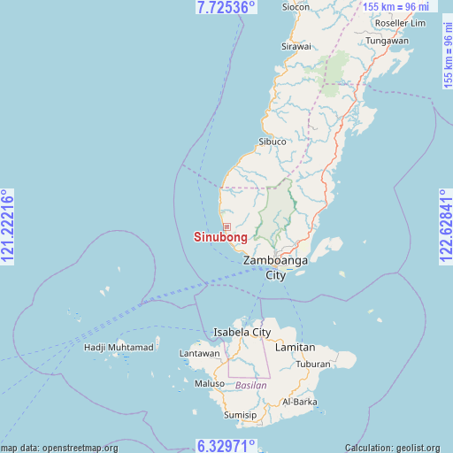
Sinubong GPS coordinates[2]
7° 1' 41.016" North, 121° 55' 31.008" East
| Map corner | latitude | longitude |
|---|---|---|
| Upper-left | 7.72536°, | 121.22216° |
| Center: | 7.02806°, | 121.92528° |
| Lower-right: | 6.32971°, | 122.62841° |
| Map W x H: | 155.2×155.2 km | = 96.4×96.4mi |
| max Lat: | 20.78733° ⇑91.4% North |
| Sinubong: | 7.02806° |
| min Lat: | ⇓8.6% South 4.65442° |
| min Long | Sinubong | max Long |
| 117.04868° | 121.92528° | 126.58417° |
| W 38.8%⇐ | ⇒61.2% E |
Elevation
Elevation of Sinubong is 33 m = 108 ft, and this is 54.9 m = 180 ft below average elevation for this country.
| Max E: |
2262 m = 7421 ft | 40.5% |
| Avg. | 87.9 m = 288 ft | |
| Sinubong | 33 m = 108 ft | |
Min E: |
-2 m = -7 ft | 59.5% |
See also: Philippines elevation on elevation.city.
Geographical zone
Sinubong is located in North Torrid zone (between Equator and Tropic of Cancer). Distance of Equator is 781.4 km =485.5 mi to South.| Distance of | km | miles | from Sinubong |
|---|---|---|---|
| North Pole | 9225.6 | 5732.5 | to North |
| Arctic Circle | 6619.7 | 4113.3 | to North |
| Tropic Cancer | 1824.5 | 1133.7 | to North |
| Equator | 781.4 | 485.5 | to South |


Nearby cities:
15 places around Sinubong: (largest is in red/bold)
• Cabaluay
28.3 km =17.6 mi,  96°
96°
• Culianan
25 km =15.5 mi, 102°
• Labuan
8.3 km =5.2 mi,  343°
343°
• Lamisahan
26.2 km =16.3 mi,  79°
79°
• Limpapa
10.3 km =6.4 mi,  350°
350°
• Lintangan
21.1 km =13.1 mi,  8°
8°
• Lumbayan
25.5 km =15.8 mi,  110°
110°
• Malayal
20.1 km =12.5 mi, 5°
• Mercedes
25.8 km =16 mi, 107°
• Recodo
9.5 km =5.9 mi,  153°
153°
• Talabaan
28.9 km =18 mi, 109°
• Talisayan
4.5 km =2.8 mi,  177°
177°
• Taluksangay
29.7 km =18.5 mi, 106°
• Tolosa
26.1 km =16.2 mi,  88°
88°
• Zamboanga
21 km =13 mi,  128°
128°
Sources, notices
• [Note1] Compared only with cities in Philippines existing in our database
• [Src1] Map data: © OpenStreetMap contributors (CC-BY-SA)
• [Src2] Other city data from geonames.org with taken over terms of usage.
• [Src3] Geographical zone / Annual Mean Temperature by Robert A. Rohde @ Wikipedia
