Libertad geodata
Libertad (Northern Mindanao) is a populated place; located in Philippines in Asia/Manila (GMT+8) time zone. With population of 4,516 people, there are 1486 cities with bigger population in this country. Compared to other cities in Philippines, 78% of cities are located further ↑North; 76.5% of cities are located further ←West and 92.7% of cities have higher elevation than Libertad. Note1
Administrative division(s):
- Level 1: Northern Mindanao
- Level 2: Province of Misamis Oriental
- Level 3: Libertad


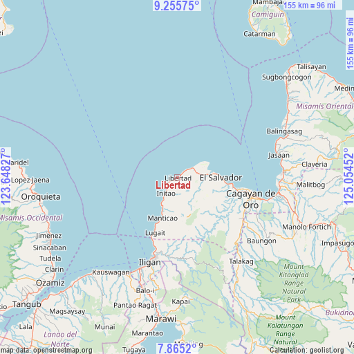
Libertad GPS coordinates[2]
8° 33' 39.996" North, 124° 21' 5.004" East
| Map corner | latitude | longitude |
|---|---|---|
| Upper-left | 9.25575°, | 123.64827° |
| Center: | 8.56111°, | 124.35139° |
| Lower-right: | 7.8652°, | 125.05452° |
| Map W x H: | 154.6×154.6 km | = 96.1×96.1mi |
| max Lat: | 20.78733° ⇑78% North |
| Libertad: | 8.56111° |
| min Lat: | ⇓22% South 4.65442° |
| min Long | Libertad | max Long |
| 117.04868° | 124.35139° | 126.58417° |
| W 76.5%⇐ | ⇒23.5% E |
Elevation
Elevation of Libertad is 6 m = 20 ft, and this is 81.9 m = 269 ft below average elevation for this country.
| Max E: |
2262 m = 7421 ft | 92.7% |
| Avg. | 87.9 m = 288 ft | |
| Libertad | 6 m = 20 ft | |
Min E: |
-2 m = -7 ft | 7.3% |
See also: Philippines elevation on elevation.city.
Geographical zone
Libertad is located in North Torrid zone (between Equator and Tropic of Cancer). Distance of Equator is 951.9 km =591.5 mi to South.| Distance of | km | miles | from Libertad |
|---|---|---|---|
| North Pole | 9055.2 | 5626.6 | to North |
| Arctic Circle | 6449.3 | 4007.4 | to North |
| Tropic Cancer | 1654 | 1027.7 | to North |
| Equator | 951.9 | 591.5 | to South |


Nearby cities:
15 places around Libertad: (largest is in red/bold)
• Alubijid
13.5 km =8.4 mi,  84°
84°
• El Salvador
18.8 km =11.7 mi,  89°
89°
• Gimampang
11.7 km =7.3 mi,  211°
211°
• Gitagum
7.2 km =4.5 mi,  56°
56°
• Initao
8.6 km =5.3 mi,  217°
217°
• Lagindingan
10.1 km =6.3 mi, 81°
• Lourdes
9.8 km =6.1 mi,  114°
114°
• Manticao
18.8 km =11.7 mi,  202°
202°
• Maputi
14.1 km =8.8 mi, 208°
• Mat-i
17.7 km =11 mi,  182°
182°
• Matangad
2.7 km =1.7 mi,  49°
49°
• Moog
13.3 km =8.3 mi,  70°
70°
• Naawan
15.7 km =9.8 mi, 206°
• Sungai
13.4 km =8.3 mi,  155°
155°
• Tubigan
5.4 km =3.4 mi,  233°
233°
Sources, notices
• [Note1] Compared only with cities in Philippines existing in our database
• [Src1] Map data: © OpenStreetMap contributors (CC-BY-SA)
• [Src2] Other city data from geonames.org with taken over terms of usage.
• [Src3] Geographical zone / Annual Mean Temperature by Robert A. Rohde @ Wikipedia
