Alubijid geodata
Alubijid (Northern Mindanao) is a seat of a third-order administrative division; located in Philippines in Asia/Manila (GMT+8) time zone. With population of 3,320 people, there are 2205 cities with bigger population in this country. Compared to other cities in Philippines, 77.9% of cities are located further ↑North; 78.6% of cities are located further ←West and 65.1% of cities have higher elevation than Alubijid. Note1
Administrative division(s):
- Level 1: Northern Mindanao
- Level 2: Province of Misamis Oriental
- Level 3: Alubijid


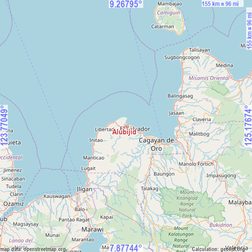
Alubijid GPS coordinates[2]
8° 34' 23.988" North, 124° 28' 24.996" East
| Map corner | latitude | longitude |
|---|---|---|
| Upper-left | 9.26795°, | 123.77049° |
| Center: | 8.57333°, | 124.47361° |
| Lower-right: | 7.87744°, | 125.17674° |
| Map W x H: | 154.6×154.6 km | = 96.1×96.1mi |
| max Lat: | 20.78733° ⇑77.9% North |
| Alubijid: | 8.57333° |
| min Lat: | ⇓22.1% South 4.65442° |
| min Long | Alubijid | max Long |
| 117.04868° | 124.47361° | 126.58417° |
| W 78.6%⇐ | ⇒21.4% E |
Elevation
Elevation of Alubijid is 14 m = 46 ft, and this is 73.9 m = 242 ft below average elevation for this country.
| Max E: |
2262 m = 7421 ft | 65.1% |
| Avg. | 87.9 m = 288 ft | |
| Alubijid | 14 m = 46 ft | |
Min E: |
-2 m = -7 ft | 34.9% |
See also: Philippines elevation on elevation.city.
Geographical zone
Alubijid is located in North Torrid zone (between Equator and Tropic of Cancer). Distance of Equator is 953.3 km =592.4 mi to South.| Distance of | km | miles | from Alubijid |
|---|---|---|---|
| North Pole | 9053.8 | 5625.8 | to North |
| Arctic Circle | 6447.9 | 4006.5 | to North |
| Tropic Cancer | 1652.7 | 1026.9 | to North |
| Equator | 953.3 | 592.4 | to South |


Nearby cities:
15 places around Alubijid: (largest is in red/bold)
• Baikingon
14.3 km =8.9 mi,  141°
141°
• Barra
16 km =9.9 mi,  115°
115°
• Bolo Bolo
6.4 km =4 mi,  105°
105°
• El Salvador
5.5 km =3.4 mi,  101°
101°
• Gitagum
7.8 km =4.8 mi,  289°
289°
• Igpit
14.2 km =8.8 mi, 119°
• Lagindingan
3.5 km =2.2 mi,  272°
272°
• Libertad
13.5 km =8.4 mi,  264°
264°
• Lourdes
7 km =4.3 mi,  220°
220°
• Matangad
11.4 km =7.1 mi, 272°
• Molugan
10.5 km =6.5 mi, 112°
• Moog
3.2 km =2 mi,  344°
344°
• Opol
12.2 km =7.6 mi, 118°
• Sungai
15.6 km =9.7 mi,  209°
209°
• Taytay
8.1 km =5 mi, 116°
Sources, notices
• [Note1] Compared only with cities in Philippines existing in our database
• [Src1] Map data: © OpenStreetMap contributors (CC-BY-SA)
• [Src2] Other city data from geonames.org with taken over terms of usage.
• [Src3] Geographical zone / Annual Mean Temperature by Robert A. Rohde @ Wikipedia
