Gitagum geodata
Gitagum (Northern Mindanao) is a seat of a third-order administrative division; located in Philippines in Asia/Manila (GMT+8) time zone. With population of 3,126 people, there are 2386 cities with bigger population in this country. Compared to other cities in Philippines, 77.7% of cities are located further ↑North; 77.6% of cities are located further ←West and 89.7% of cities have higher elevation than Gitagum. Note1
Administrative division(s):
- Level 1: Northern Mindanao
- Level 2: Province of Misamis Oriental
- Level 3: Gitagum


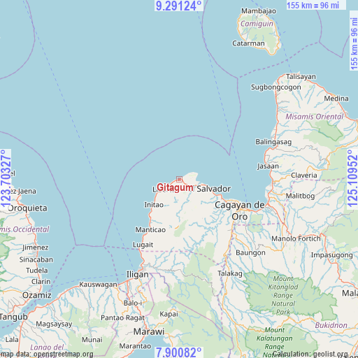
Gitagum GPS coordinates[2]
8° 35' 48.012" North, 124° 24' 23.004" East
| Map corner | latitude | longitude |
|---|---|---|
| Upper-left | 9.29124°, | 123.70327° |
| Center: | 8.59667°, | 124.40639° |
| Lower-right: | 7.90082°, | 125.10952° |
| Map W x H: | 154.6×154.6 km | = 96.1×96.1mi |
| max Lat: | 20.78733° ⇑77.7% North |
| Gitagum: | 8.59667° |
| min Lat: | ⇓22.3% South 4.65442° |
| min Long | Gitagum | max Long |
| 117.04868° | 124.40639° | 126.58417° |
| W 77.6%⇐ | ⇒22.4% E |
Elevation
Elevation of Gitagum is 7 m = 23 ft, and this is 80.9 m = 265 ft below average elevation for this country.
| Max E: |
2262 m = 7421 ft | 89.7% |
| Avg. | 87.9 m = 288 ft | |
| Gitagum | 7 m = 23 ft | |
Min E: |
-2 m = -7 ft | 10.3% |
See also: Philippines elevation on elevation.city.
Geographical zone
Gitagum is located in North Torrid zone (between Equator and Tropic of Cancer). Distance of Equator is 955.9 km =594 mi to South.| Distance of | km | miles | from Gitagum |
|---|---|---|---|
| North Pole | 9051.2 | 5624.2 | to North |
| Arctic Circle | 6445.3 | 4004.9 | to North |
| Tropic Cancer | 1650.1 | 1025.3 | to North |
| Equator | 955.9 | 594 | to South |


Nearby cities:
15 places around Gitagum: (largest is in red/bold)
• Alubijid
7.8 km =4.8 mi,  109°
109°
• Bolo Bolo
14.2 km =8.8 mi, 107°
• El Salvador
13.3 km =8.3 mi, 106°
• Gimampang
18.4 km =11.4 mi,  220°
220°
• Initao
15.6 km =9.7 mi,  226°
226°
• Lagindingan
4.6 km =2.9 mi,  121°
121°
• Libertad
7.2 km =4.5 mi,  236°
236°
• Lourdes
8.5 km =5.3 mi,  160°
160°
• Matangad
4.6 km =2.9 mi, 241°
• Molugan
18.4 km =11.4 mi, 111°
• Moog
6.6 km =4.1 mi,  85°
85°
• Opol
20 km =12.4 mi, 114°
• Sungai
16.2 km =10.1 mi,  181°
181°
• Taytay
15.9 km =9.9 mi, 112°
• Tubigan
12.6 km =7.8 mi, 235°
Sources, notices
• [Note1] Compared only with cities in Philippines existing in our database
• [Src1] Map data: © OpenStreetMap contributors (CC-BY-SA)
• [Src2] Other city data from geonames.org with taken over terms of usage.
• [Src3] Geographical zone / Annual Mean Temperature by Robert A. Rohde @ Wikipedia
