Maputi geodata
Maputi (Northern Mindanao) is a populated place; located in Philippines in Asia/Manila (GMT+8) time zone. With population of 2,304 people, there are 3674 cities with bigger population in this country. Compared to other cities in Philippines, 79.2% of cities are located further ↑North; 75.3% of cities are located further ←West and 73.2% of cities have higher elevation than Maputi. Note1
Administrative division(s):
- Level 1: Northern Mindanao
- Level 2: Province of Misamis Oriental
- Level 3: Naawan


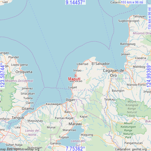
Maputi GPS coordinates[2]
8° 26' 58.992" North, 124° 17' 26.016" East
| Map corner | latitude | longitude |
|---|---|---|
| Upper-left | 9.14457°, | 123.58744° |
| Center: | 8.44972°, | 124.29056° |
| Lower-right: | 7.75362°, | 124.99369° |
| Map W x H: | 154.7×154.7 km | = 96.1×96.1mi |
| max Lat: | 20.78733° ⇑79.2% North |
| Maputi: | 8.44972° |
| min Lat: | ⇓20.8% South 4.65442° |
| min Long | Maputi | max Long |
| 117.04868° | 124.29056° | 126.58417° |
| W 75.3%⇐ | ⇒24.7% E |
Elevation
Elevation of Maputi is 11 m = 36 ft, and this is 76.9 m = 252 ft below average elevation for this country.
| Max E: |
2262 m = 7421 ft | 73.2% |
| Avg. | 87.9 m = 288 ft | |
| Maputi | 11 m = 36 ft | |
Min E: |
-2 m = -7 ft | 26.8% |
See also: Philippines elevation on elevation.city.
Geographical zone
Maputi is located in North Torrid zone (between Equator and Tropic of Cancer). Distance of Equator is 939.5 km =583.8 mi to South.| Distance of | km | miles | from Maputi |
|---|---|---|---|
| North Pole | 9067.5 | 5634.3 | to North |
| Arctic Circle | 6461.7 | 4015.1 | to North |
| Tropic Cancer | 1666.4 | 1035.5 | to North |
| Equator | 939.5 | 583.8 | to South |


Nearby cities:
15 places around Maputi: (largest is in red/bold)
• Biga
10.8 km =6.7 mi,  198°
198°
• Buawan
14.9 km =9.3 mi,  174°
174°
• Dalipuga
15.4 km =9.6 mi,  194°
194°
• Gimampang
2.5 km =1.6 mi,  15°
15°
• Initao
5.7 km =3.5 mi,  14°
14°
• Kabalantian
9.7 km =6 mi,  155°
155°
• Libertad
14.1 km =8.8 mi,  28°
28°
• Lugait
12.6 km =7.8 mi, 195°
• Manticao
5.1 km =3.2 mi,  184°
184°
• Mat-i
8 km =5 mi,  131°
131°
• Naawan
1.7 km =1.1 mi, 186°
• Punta Silum
7.9 km =4.9 mi, 197°
• Sungai
12.3 km =7.6 mi,  89°
89°
• Tubigan
9.5 km =5.9 mi, 14°
• Tuod
13.7 km =8.5 mi,  149°
149°
Sources, notices
• [Note1] Compared only with cities in Philippines existing in our database
• [Src1] Map data: © OpenStreetMap contributors (CC-BY-SA)
• [Src2] Other city data from geonames.org with taken over terms of usage.
• [Src3] Geographical zone / Annual Mean Temperature by Robert A. Rohde @ Wikipedia
