Libas geodata
Libas (Eastern Visayas) is a populated place; located in Philippines in Asia/Manila (GMT+8) time zone. With population of 2,056 people, there are 4129 cities with bigger population in this country. Compared to other cities in Philippines, 57.5% of cities are located further ↑North; 79.6% of cities are located further ←West and 80.7% of cities have higher elevation than Libas. Note1


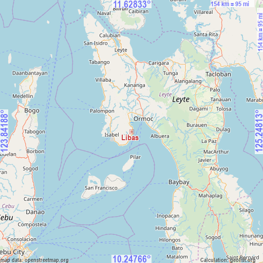
Libas GPS coordinates[2]
10° 56' 19.68" North, 124° 32' 42" East
| Map corner | latitude | longitude |
|---|---|---|
| Upper-left | 11.62833°, | 123.84188° |
| Center: | 10.9388°, | 124.545° |
| Lower-right: | 10.24766°, | 125.24813° |
| Map W x H: | 153.5×153.5 km | = 95.4×95.4mi |
| max Lat: | 20.78733° ⇑57.5% North |
| Libas: | 10.9388° |
| min Lat: | ⇓42.5% South 4.65442° |
| min Long | Libas | max Long |
| 117.04868° | 124.545° | 126.58417° |
| W 79.6%⇐ | ⇒20.4% E |
Elevation
Elevation of Libas is 9 m = 30 ft, and this is 78.9 m = 259 ft below average elevation for this country.
| Max E: |
2262 m = 7421 ft | 80.7% |
| Avg. | 87.9 m = 288 ft | |
| Libas | 9 m = 30 ft | |
Min E: |
-2 m = -7 ft | 19.3% |
See also: Philippines elevation on elevation.city.
Geographical zone
Libas is located in North Torrid zone (between Equator and Tropic of Cancer). Distance of Equator is 1216.3 km =755.8 mi to South.| Distance of | km | miles | from Libas |
|---|---|---|---|
| North Pole | 8790.8 | 5462.3 | to North |
| Arctic Circle | 6184.9 | 3843.1 | to North |
| Tropic Cancer | 1389.6 | 863.5 | to North |
| Equator | 1216.3 | 755.8 | to South |


Nearby cities:
15 places around Libas: (largest is in red/bold)
• Bilwang
10.5 km =6.5 mi,  234°
234°
• Ipil
10.7 km =6.6 mi,  68°
68°
• Isabel
12.2 km =7.6 mi,  263°
263°
• Lao
9 km =5.6 mi,  10°
10°
• Libertad
10.7 km =6.6 mi, 256°
• Libertad
11.1 km =6.9 mi, 13°
• Liloan
11.7 km =7.3 mi,  2°
2°
• Margen
8.9 km =5.5 mi,  348°
348°
• Matlang
11.2 km =7 mi,  241°
241°
• Merida
3.3 km =2.1 mi,  194°
194°
• Ormoc
10.2 km =6.3 mi,  42°
42°
• Puerto Bello
4 km =2.5 mi,  344°
344°
• San Isidro
12.8 km =8 mi,  282°
282°
• San Juan
6.9 km =4.3 mi, 354°
• Tugbong
10.5 km =6.5 mi,  34°
34°
Sources, notices
• [Note1] Compared only with cities in Philippines existing in our database
• [Src1] Map data: © OpenStreetMap contributors (CC-BY-SA)
• [Src2] Other city data from geonames.org with taken over terms of usage.
• [Src3] Geographical zone / Annual Mean Temperature by Robert A. Rohde @ Wikipedia
