Ipil geodata
Ipil (Eastern Visayas) is a populated place; located in Philippines in Asia/Manila (GMT+8) time zone. With population of 3,854 people, there are 1807 cities with bigger population in this country. Compared to other cities in Philippines, 57.1% of cities are located further ↑North; 81.4% of cities are located further ←West and 89.7% of cities have higher elevation than Ipil. Note1


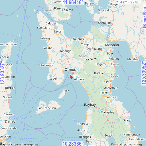
Ipil GPS coordinates[2]
10° 58' 28.992" North, 124° 38' 11.004" East
| Map corner | latitude | longitude |
|---|---|---|
| Upper-left | 11.66416°, | 123.93327° |
| Center: | 10.97472°, | 124.63639° |
| Lower-right: | 10.28366°, | 125.33952° |
| Map W x H: | 153.5×153.5 km | = 95.4×95.4mi |
| max Lat: | 20.78733° ⇑57.1% North |
| Ipil: | 10.97472° |
| min Lat: | ⇓42.9% South 4.65442° |
| min Long | Ipil | max Long |
| 117.04868° | 124.63639° | 126.58417° |
| W 81.4%⇐ | ⇒18.6% E |
Elevation
Elevation of Ipil is 7 m = 23 ft, and this is 80.9 m = 265 ft below average elevation for this country.
| Max E: |
2262 m = 7421 ft | 89.7% |
| Avg. | 87.9 m = 288 ft | |
| Ipil | 7 m = 23 ft | |
Min E: |
-2 m = -7 ft | 10.3% |
See also: Philippines elevation on elevation.city.
Geographical zone
Ipil is located in North Torrid zone (between Equator and Tropic of Cancer). Distance of Equator is 1220.3 km =758.3 mi to South.| Distance of | km | miles | from Ipil |
|---|---|---|---|
| North Pole | 8786.8 | 5459.9 | to North |
| Arctic Circle | 6180.9 | 3840.6 | to North |
| Tropic Cancer | 1385.6 | 861 | to North |
| Equator | 1220.3 | 758.3 | to South |


Nearby cities:
15 places around Ipil: (largest is in red/bold)
• Albuera
9.1 km =5.7 mi,  135°
135°
• Balogo
12.7 km =7.9 mi, 140°
• Dolores
10 km =6.2 mi,  345°
345°
• Lao
9.7 km =6 mi,  299°
299°
• Libas
10.7 km =6.6 mi,  248°
248°
• Libertad
10.1 km =6.3 mi,  312°
312°
• Liloan
12.1 km =7.5 mi, 309°
• Margen
12.7 km =7.9 mi,  291°
291°
• Ormoc
4.7 km =2.9 mi,  318°
318°
• Puerto Bello
11.1 km =6.9 mi,  269°
269°
• San Juan
11 km =6.8 mi, 285°
• Santo Niño
12.8 km =8 mi, 320°
• Siguinon
6 km =3.7 mi,  126°
126°
• Talisayan
7.5 km =4.7 mi,  111°
111°
• Tugbong
6.1 km =3.8 mi, 319°
Sources, notices
• [Note1] Compared only with cities in Philippines existing in our database
• [Src1] Map data: © OpenStreetMap contributors (CC-BY-SA)
• [Src2] Other city data from geonames.org with taken over terms of usage.
• [Src3] Geographical zone / Annual Mean Temperature by Robert A. Rohde @ Wikipedia
