Liloan geodata
Liloan (Eastern Visayas) is a populated place; located in Philippines in Asia/Manila (GMT+8) time zone. With population of 3,521 people, there are 2041 cities with bigger population in this country. Compared to other cities in Philippines, 56.4% of cities are located further ↑North; 79.6% of cities are located further ←West and 85.4% of cities have higher elevation than Liloan. Note1


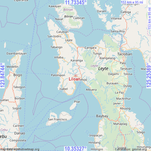
Liloan GPS coordinates[2]
11° 2' 39.012" North, 124° 33' 2.016" East
| Map corner | latitude | longitude |
|---|---|---|
| Upper-left | 11.73345°, | 123.84744° |
| Center: | 11.04417°, | 124.55056° |
| Lower-right: | 10.35327°, | 125.25369° |
| Map W x H: | 153.5×153.5 km | = 95.4×95.4mi |
| max Lat: | 20.78733° ⇑56.4% North |
| Liloan: | 11.04417° |
| min Lat: | ⇓43.6% South 4.65442° |
| min Long | Liloan | max Long |
| 117.04868° | 124.55056° | 126.58417° |
| W 79.6%⇐ | ⇒20.4% E |
Elevation
Elevation of Liloan is 8 m = 26 ft, and this is 79.9 m = 262 ft below average elevation for this country.
| Max E: |
2262 m = 7421 ft | 85.4% |
| Avg. | 87.9 m = 288 ft | |
| Liloan | 8 m = 26 ft | |
Min E: |
-2 m = -7 ft | 14.6% |
See also: Philippines elevation on elevation.city.
Geographical zone
Liloan is located in North Torrid zone (between Equator and Tropic of Cancer). Distance of Equator is 1228 km =763 mi to South.| Distance of | km | miles | from Liloan |
|---|---|---|---|
| North Pole | 8779.1 | 5455.1 | to North |
| Arctic Circle | 6173.2 | 3835.8 | to North |
| Tropic Cancer | 1377.9 | 856.2 | to North |
| Equator | 1228 | 763 | to South |


Nearby cities:
15 places around Liloan: (largest is in red/bold)
• Balagtas
10.5 km =6.5 mi,  340°
340°
• Dolores
7.1 km =4.4 mi,  74°
74°
• Lao
3.1 km =1.9 mi,  160°
160°
• Libertad
2.1 km =1.3 mi,  114°
114°
• Malilinao
8.8 km =5.5 mi,  322°
322°
• Margen
3.9 km =2.4 mi,  218°
218°
• Masarayao
8.9 km =5.5 mi,  55°
55°
• Naghalin
11.4 km =7.1 mi,  9°
9°
• Ormoc
7.5 km =4.7 mi,  124°
124°
• Puerto Bello
8.1 km =5 mi,  192°
192°
• San Juan
5 km =3.1 mi, 194°
• San Vicente
8.4 km =5.2 mi, 11°
• Santo Niño
2.4 km =1.5 mi,  29°
29°
• Tugbong
6.2 km =3.9 mi, 119°
• Valencia
7.6 km =4.7 mi,  18°
18°
Sources, notices
• [Note1] Compared only with cities in Philippines existing in our database
• [Src1] Map data: © OpenStreetMap contributors (CC-BY-SA)
• [Src2] Other city data from geonames.org with taken over terms of usage.
• [Src3] Geographical zone / Annual Mean Temperature by Robert A. Rohde @ Wikipedia
