San Juan geodata
San Juan (Eastern Visayas) is a populated place; located in Philippines in Asia/Manila (GMT+8) time zone. With population of 2,056 people, there are 4129 cities with bigger population in this country. Compared to other cities in Philippines, 56.9% of cities are located further ↑North; 79.5% of cities are located further ←West and 89.7% of cities have higher elevation than San Juan. Note1


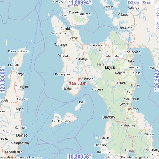
San Juan GPS coordinates[2]
11° 0' 2.016" North, 124° 32' 21.012" East
| Map corner | latitude | longitude |
|---|---|---|
| Upper-left | 11.68994°, | 123.83605° |
| Center: | 11.00056°, | 124.53917° |
| Lower-right: | 10.30956°, | 125.2423° |
| Map W x H: | 153.5×153.5 km | = 95.4×95.4mi |
| max Lat: | 20.78733° ⇑56.9% North |
| San Juan: | 11.00056° |
| min Lat: | ⇓43.1% South 4.65442° |
| min Long | San Juan | max Long |
| 117.04868° | 124.53917° | 126.58417° |
| W 79.5%⇐ | ⇒20.5% E |
Elevation
Elevation of San Juan is 7 m = 23 ft, and this is 80.9 m = 265 ft below average elevation for this country.
| Max E: |
2262 m = 7421 ft | 89.7% |
| Avg. | 87.9 m = 288 ft | |
| San Juan | 7 m = 23 ft | |
Min E: |
-2 m = -7 ft | 10.3% |
See also: Philippines elevation on elevation.city.
Geographical zone
San Juan is located in North Torrid zone (between Equator and Tropic of Cancer). Distance of Equator is 1223.1 km =760 mi to South.| Distance of | km | miles | from San Juan |
|---|---|---|---|
| North Pole | 8783.9 | 5458.1 | to North |
| Arctic Circle | 6178 | 3838.8 | to North |
| Tropic Cancer | 1382.8 | 859.2 | to North |
| Equator | 1223.1 | 760 | to South |


Nearby cities:
15 places around San Juan: (largest is in red/bold)
• Dolores
10.5 km =6.5 mi,  50°
50°
• Ipil
11 km =6.8 mi,  105°
105°
• Lao
3 km =1.9 mi, 49°
• Libas
6.9 km =4.3 mi,  174°
174°
• Libertad
5.1 km =3.2 mi,  38°
38°
• Liloan
5 km =3.1 mi,  14°
14°
• Malilinao
12.5 km =7.8 mi,  340°
340°
• Margen
2.2 km =1.4 mi,  327°
327°
• Merida
10.1 km =6.3 mi,  180°
180°
• Ormoc
7.5 km =4.7 mi,  85°
85°
• Puerto Bello
3.1 km =1.9 mi,  188°
188°
• San Isidro
12.6 km =7.8 mi,  250°
250°
• Santo Niño
7.4 km =4.6 mi,  19°
19°
• Tugbong
6.9 km =4.3 mi,  74°
74°
• Valencia
12.6 km =7.8 mi, 16°
Sources, notices
• [Note1] Compared only with cities in Philippines existing in our database
• [Src1] Map data: © OpenStreetMap contributors (CC-BY-SA)
• [Src2] Other city data from geonames.org with taken over terms of usage.
• [Src3] Geographical zone / Annual Mean Temperature by Robert A. Rohde @ Wikipedia
