Leuteboro geodata
Leuteboro (Mimaropa) is a populated place; located in Philippines in Asia/Manila (GMT+8) time zone. With population of 3,802 people, there are 1841 cities with bigger population in this country. Compared to other cities in Philippines, 57.8% of cities are located further ↓South; 69% of cities are located further →East and 54.4% of cities have lower elevation than Leuteboro. Note1
Administrative division(s):
- Level 1: Mimaropa
- Level 2: Province of Mindoro Oriental
- Level 3: Socorro


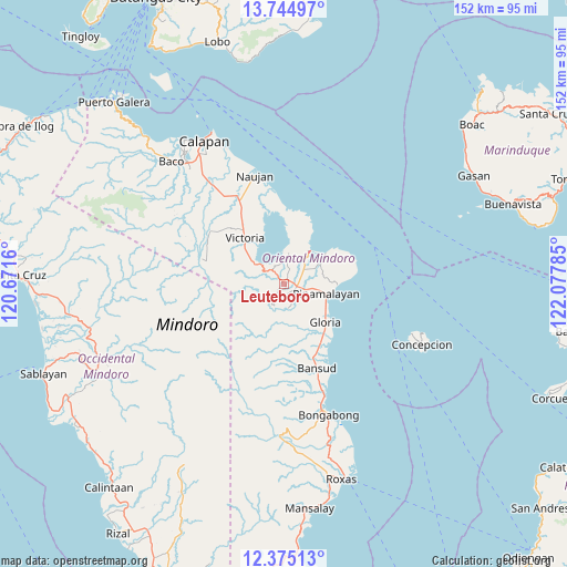
Leuteboro GPS coordinates[2]
13° 3' 39.6" North, 121° 22' 28.992" East
| Map corner | latitude | longitude |
|---|---|---|
| Upper-left | 13.74497°, | 120.6716° |
| Center: | 13.061°, | 121.37472° |
| Lower-right: | 12.37513°, | 122.07785° |
| Map W x H: | 152.3×152.3 km | = 94.6×94.6mi |
| max Lat: | 20.78733° ⇑42.2% North |
| Leuteboro: | 13.061° |
| min Lat: | ⇓57.8% South 4.65442° |
| min Long | Leuteboro | max Long |
| 117.04868° | 121.37472° | 126.58417° |
| W 31%⇐ | ⇒69% E |
Elevation
Elevation of Leuteboro is 27 m = 89 ft, and this is 60.9 m = 200 ft below average elevation for this country.
| Max E: |
2262 m = 7421 ft | 45.6% |
| Avg. | 87.9 m = 288 ft | |
| Leuteboro | 27 m = 89 ft | |
Min E: |
-2 m = -7 ft | 54.4% |
See also: Philippines elevation on elevation.city.
Geographical zone
Leuteboro is located in North Torrid zone (between Equator and Tropic of Cancer). Distance of this Northern Tropic circle is 1153.7 km =716.9 mi to North.| Distance of | km | miles | from Leuteboro |
|---|---|---|---|
| North Pole | 8554.8 | 5315.7 | to North |
| Arctic Circle | 5948.9 | 3696.5 | to North |
| Tropic Cancer | 1153.7 | 716.9 | to North |
| Equator | 1452.2 | 902.4 | to South |


Nearby cities:
15 places around Leuteboro: (largest is in red/bold)
• Bayuin
2.7 km =1.7 mi,  145°
145°
• Gloria
13.2 km =8.2 mi,  130°
130°
• Lumangbayan
13.5 km =8.4 mi,  96°
96°
• Malamig
12.4 km =7.7 mi,  184°
184°
• Maluanluan
6.6 km =4.1 mi,  53°
53°
• Pambisan
6.7 km =4.2 mi,  141°
141°
• Pangulayan
8.3 km =5.2 mi,  106°
106°
• Pili
15.8 km =9.8 mi,  87°
87°
• Pinamalayan
9.6 km =6 mi, 99°
• Pola
11.7 km =7.3 mi,  38°
38°
• Quinabigan
13.5 km =8.4 mi,  123°
123°
• Saaban
7.8 km =4.8 mi,  355°
355°
• Socorro
2.7 km =1.7 mi,  75°
75°
• Tambong
16.1 km =10 mi, 132°
• Victoria
16.6 km =10.3 mi,  320°
320°
Sources, notices
• [Note1] Compared only with cities in Philippines existing in our database
• [Src1] Map data: © OpenStreetMap contributors (CC-BY-SA)
• [Src2] Other city data from geonames.org with taken over terms of usage.
• [Src3] Geographical zone / Annual Mean Temperature by Robert A. Rohde @ Wikipedia
