Saaban geodata
Saaban (Mimaropa) is a populated place; located in Philippines in Asia/Manila (GMT+8) time zone. With population of 2,527 people, there are 3248 cities with bigger population in this country. Compared to other cities in Philippines, 58.3% of cities are located further ↓South; 69.1% of cities are located further →East and 85.4% of cities have higher elevation than Saaban. Note1


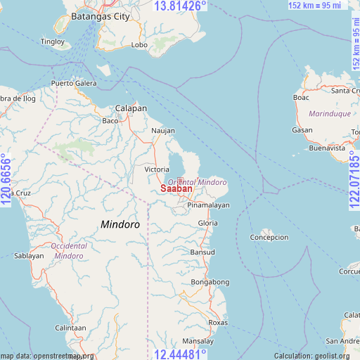
Saaban GPS coordinates[2]
13° 7' 49.764" North, 121° 22' 7.392" East
| Map corner | latitude | longitude |
|---|---|---|
| Upper-left | 13.81426°, | 120.6656° |
| Center: | 13.13049°, | 121.36872° |
| Lower-right: | 12.44481°, | 122.07185° |
| Map W x H: | 152.3×152.3 km | = 94.6×94.6mi |
| max Lat: | 20.78733° ⇑41.7% North |
| Saaban: | 13.13049° |
| min Lat: | ⇓58.3% South 4.65442° |
| min Long | Saaban | max Long |
| 117.04868° | 121.36872° | 126.58417° |
| W 30.9%⇐ | ⇒69.1% E |
Elevation
Elevation of Saaban is 8 m = 26 ft, and this is 79.9 m = 262 ft below average elevation for this country.
| Max E: |
2262 m = 7421 ft | 85.4% |
| Avg. | 87.9 m = 288 ft | |
| Saaban | 8 m = 26 ft | |
Min E: |
-2 m = -7 ft | 14.6% |
See also: Philippines elevation on elevation.city.
Geographical zone
Saaban is located in North Torrid zone (between Equator and Tropic of Cancer). Distance of this Northern Tropic circle is 1145.9 km =712 mi to North.| Distance of | km | miles | from Saaban |
|---|---|---|---|
| North Pole | 8547.1 | 5310.9 | to North |
| Arctic Circle | 5941.2 | 3691.7 | to North |
| Tropic Cancer | 1145.9 | 712 | to North |
| Equator | 1460 | 907.2 | to South |


Nearby cities:
15 places around Saaban: (largest is in red/bold)
• Bayuin
10.2 km =6.3 mi,  167°
167°
• Gloria
19.5 km =12.1 mi,  147°
147°
• Leuteboro
7.8 km =4.8 mi,  175°
175°
• Lumangbayan
16.8 km =10.4 mi,  122°
122°
• Maluanluan
7 km =4.3 mi, 122°
• Pambisan
13.8 km =8.6 mi,  159°
159°
• Pangulayan
13.2 km =8.2 mi,  139°
139°
• Pili
17.9 km =11.1 mi,  113°
113°
• Pinagsabangan
18.6 km =11.6 mi,  324°
324°
• Pinamalayan
13.8 km =8.6 mi,  132°
132°
• Pola
8 km =5 mi,  79°
79°
• Quinabigan
19.3 km =12 mi, 142°
• San Agustin
17.7 km =11 mi,  337°
337°
• Socorro
7.8 km =4.8 mi, 155°
• Victoria
11.1 km =6.9 mi,  297°
297°
Sources, notices
• [Note1] Compared only with cities in Philippines existing in our database
• [Src1] Map data: © OpenStreetMap contributors (CC-BY-SA)
• [Src2] Other city data from geonames.org with taken over terms of usage.
• [Src3] Geographical zone / Annual Mean Temperature by Robert A. Rohde @ Wikipedia
