Victoria geodata
Victoria (Mimaropa) is a seat of a third-order administrative division; located in Philippines in Asia/Manila (GMT+8) time zone. With population of 10,088 people, there are 606 cities with bigger population in this country. Compared to other cities in Philippines, 58.6% of cities are located further ↓South; 70.5% of cities are located further →East and 57.6% of cities have higher elevation than Victoria. Note1
Administrative division(s):
- Level 1: Mimaropa
- Level 2: Province of Mindoro Oriental
- Level 3: Victoria


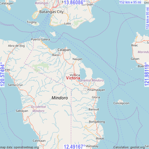
Victoria GPS coordinates[2]
13° 10' 37.992" North, 121° 16' 41.016" East
| Map corner | latitude | longitude |
|---|---|---|
| Upper-left | 13.86086°, | 120.57494° |
| Center: | 13.17722°, | 121.27806° |
| Lower-right: | 12.49167°, | 121.98119° |
| Map W x H: | 152.2×152.2 km | = 94.6×94.6mi |
| max Lat: | 20.78733° ⇑41.4% North |
| Victoria: | 13.17722° |
| min Lat: | ⇓58.6% South 4.65442° |
| min Long | Victoria | max Long |
| 117.04868° | 121.27806° | 126.58417° |
| W 29.5%⇐ | ⇒70.5% E |
Elevation
Elevation of Victoria is 18 m = 59 ft, and this is 69.9 m = 229 ft below average elevation for this country.
| Max E: |
2262 m = 7421 ft | 57.6% |
| Avg. | 87.9 m = 288 ft | |
| Victoria | 18 m = 59 ft | |
Min E: |
-2 m = -7 ft | 42.4% |
See also: Philippines elevation on elevation.city.
Geographical zone
Victoria is located in North Torrid zone (between Equator and Tropic of Cancer). Distance of this Northern Tropic circle is 1140.7 km =708.8 mi to North.| Distance of | km | miles | from Victoria |
|---|---|---|---|
| North Pole | 8541.9 | 5307.7 | to North |
| Arctic Circle | 5936 | 3688.5 | to North |
| Tropic Cancer | 1140.7 | 708.8 | to North |
| Equator | 1465.2 | 910.4 | to South |


Nearby cities:
15 places around Victoria: (largest is in red/bold)
• Apitong
10.3 km =6.4 mi,  312°
312°
• Aurora
18.1 km =11.2 mi,  289°
289°
• Bayuin
19.3 km =12 mi,  141°
141°
• Communal
17.6 km =10.9 mi,  299°
299°
• Estrella
17.2 km =10.7 mi,  11°
11°
• Leuteboro
16.6 km =10.3 mi, 140°
• Maluanluan
18.1 km =11.2 mi,  119°
119°
• Manogpi
16.9 km =10.5 mi,  331°
331°
• Nagiba
17 km =10.6 mi,  358°
358°
• Naujan
16.5 km =10.3 mi, 9°
• Pinagsabangan
9.9 km =6.2 mi,  353°
353°
• Pola
18.1 km =11.2 mi,  101°
101°
• Saaban
11.1 km =6.9 mi, 117°
• San Agustin
11.5 km =7.1 mi, 14°
• Socorro
17.9 km =11.1 mi,  133°
133°
Sources, notices
• [Note1] Compared only with cities in Philippines existing in our database
• [Src1] Map data: © OpenStreetMap contributors (CC-BY-SA)
• [Src2] Other city data from geonames.org with taken over terms of usage.
• [Src3] Geographical zone / Annual Mean Temperature by Robert A. Rohde @ Wikipedia
