Oslob geodata
Oslob (Central Visayas) is a seat of a third-order administrative division; located in Philippines in Asia/Manila (GMT+8) time zone. With population of 3,724 people, there are 1901 cities with bigger population in this country. Compared to other cities in Philippines, 73.1% of cities are located further ↑North; 61% of cities are located further ←West and 89.7% of cities have higher elevation than Oslob. Note1


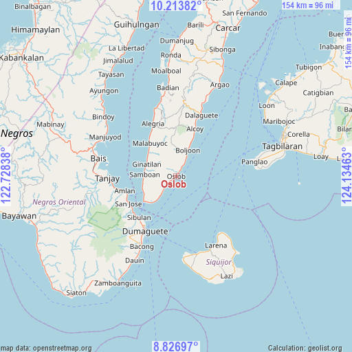
Oslob GPS coordinates[2]
9° 31' 15.96" North, 123° 25' 53.4" East
| Map corner | latitude | longitude |
|---|---|---|
| Upper-left | 10.21382°, | 122.72838° |
| Center: | 9.5211°, | 123.4315° |
| Lower-right: | 8.82697°, | 124.13463° |
| Map W x H: | 154.2×154.2 km | = 95.8×95.8mi |
| max Lat: | 20.78733° ⇑73.1% North |
| Oslob: | 9.5211° |
| min Lat: | ⇓26.9% South 4.65442° |
| min Long | Oslob | max Long |
| 117.04868° | 123.4315° | 126.58417° |
| W 61%⇐ | ⇒39% E |
Elevation
Elevation of Oslob is 7 m = 23 ft, and this is 80.9 m = 265 ft below average elevation for this country.
| Max E: |
2262 m = 7421 ft | 89.7% |
| Avg. | 87.9 m = 288 ft | |
| Oslob | 7 m = 23 ft | |
Min E: |
-2 m = -7 ft | 10.3% |
See also: Philippines elevation on elevation.city.
Geographical zone
Oslob is located in North Torrid zone (between Equator and Tropic of Cancer). Distance of Equator is 1058.6 km =657.8 mi to South.| Distance of | km | miles | from Oslob |
|---|---|---|---|
| North Pole | 8948.4 | 5560.3 | to North |
| Arctic Circle | 6342.5 | 3941 | to North |
| Tropic Cancer | 1547.3 | 961.4 | to North |
| Equator | 1058.6 | 657.8 | to South |


Nearby cities:
15 places around Oslob: (largest is in red/bold)
• Alcoy
22.6 km =14 mi,  21°
21°
• Becerril
14.7 km =9.1 mi,  1°
1°
• Boljoon
13 km =8.1 mi, 23°
• El Pardo
16.9 km =10.5 mi, 24°
• Ginatilan
14.1 km =8.8 mi,  292°
292°
• Guadalupe
22.8 km =14.2 mi,  351°
351°
• Lepanto
18.4 km =11.4 mi, 350°
• Mainit
12.5 km =7.8 mi,  219°
219°
• Malabuyoc
18.7 km =11.6 mi,  321°
321°
• Montaneza
21.4 km =13.3 mi,  328°
328°
• Nugas
19.6 km =12.2 mi, 3°
• Samboan
13.7 km =8.5 mi,  273°
273°
• Santander Poblacion
14.7 km =9.1 mi, 223°
• Talangnan
16.5 km =10.3 mi, 319°
• Tandayag
23.3 km =14.5 mi,  251°
251°
Sources, notices
• [Note1] Compared only with cities in Philippines existing in our database
• [Src1] Map data: © OpenStreetMap contributors (CC-BY-SA)
• [Src2] Other city data from geonames.org with taken over terms of usage.
• [Src3] Geographical zone / Annual Mean Temperature by Robert A. Rohde @ Wikipedia
