Kalbay geodata
Kalbay (Davao) is a populated place; located in Philippines in Asia/Manila (GMT+8) time zone. With population of 4,339 people, there are 1565 cities with bigger population in this country. Compared to other cities in Philippines, 99.1% of cities are located further ↑North; 93.5% of cities are located further ←West and 67.5% of cities have lower elevation than Kalbay. Note1
Administrative division(s):
- Level 1: Davao
- Level 2: Davao Occidental
- Level 3: Jose Abad Santos (Trinidad)


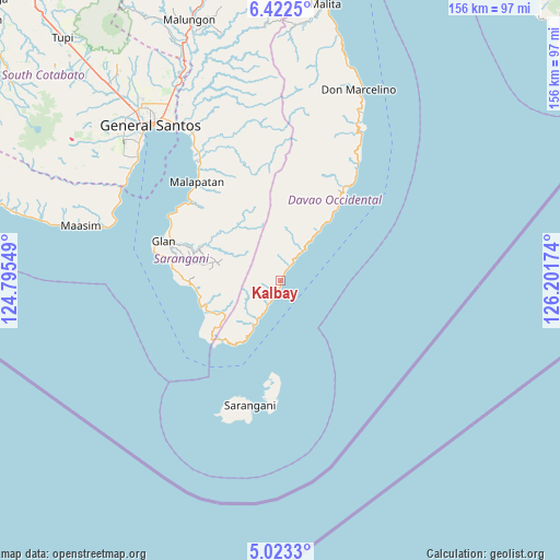
Kalbay GPS coordinates[2]
5° 43' 23.988" North, 125° 29' 54.996" East
| Map corner | latitude | longitude |
|---|---|---|
| Upper-left | 6.4225°, | 124.79549° |
| Center: | 5.72333°, | 125.49861° |
| Lower-right: | 5.0233°, | 126.20174° |
| Map W x H: | 155.6×155.6 km | = 96.7×96.7mi |
| max Lat: | 20.78733° ⇑99.1% North |
| Kalbay: | 5.72333° |
| min Lat: | ⇓0.9% South 4.65442° |
| min Long | Kalbay | max Long |
| 117.04868° | 125.49861° | 126.58417° |
| W 93.5%⇐ | ⇒6.5% E |
Elevation
Elevation of Kalbay is 47 m = 154 ft, and this is 40.9 m = 134 ft below average elevation for this country.
| Max E: |
2262 m = 7421 ft | 32.5% |
| Avg. | 87.9 m = 288 ft | |
| Kalbay | 47 m = 154 ft | |
Min E: |
-2 m = -7 ft | 67.5% |
See also: Philippines elevation on elevation.city.
Geographical zone
Kalbay is located in North Torrid zone (between Equator and Tropic of Cancer). Distance of Equator is 636.4 km =395.4 mi to South.| Distance of | km | miles | from Kalbay |
|---|---|---|---|
| North Pole | 9370.7 | 5822.7 | to North |
| Arctic Circle | 6764.8 | 4203.5 | to North |
| Tropic Cancer | 1969.5 | 1223.8 | to North |
| Equator | 636.4 | 395.4 | to South |


Nearby cities:
15 places around Kalbay: (largest is in red/bold)
• Balangonan
23.1 km =14.4 mi,  223°
223°
• Baliton
29.1 km =18.1 mi,  274°
274°
• Bukid
19.8 km =12.3 mi,  211°
211°
• Burias
27.1 km =16.8 mi, 268°
• Butulan
14.2 km =8.8 mi, 211°
• Caburan
26.8 km =16.7 mi,  36°
36°
• Culaman
31.7 km =19.7 mi,  33°
33°
• Glan Peidu
34.3 km =21.3 mi,  295°
295°
• Ilaya
31.8 km =19.8 mi,  288°
288°
• Kablalan
33.9 km =21.1 mi,  280°
280°
• Kiupo
23.8 km =14.8 mi, 303°
• Nuing
12.3 km =7.6 mi, 214°
• Pangyan
24.2 km =15 mi,  264°
264°
• Sapu Padidu
33.5 km =20.8 mi,  310°
310°
• Sugal
7.9 km =4.9 mi, 211°
Sources, notices
• [Note1] Compared only with cities in Philippines existing in our database
• [Src1] Map data: © OpenStreetMap contributors (CC-BY-SA)
• [Src2] Other city data from geonames.org with taken over terms of usage.
• [Src3] Geographical zone / Annual Mean Temperature by Robert A. Rohde @ Wikipedia
