Kalayaan geodata
Kalayaan (Calabarzon) is a seat of a third-order administrative division; located in Philippines in Asia/Manila (GMT+8) time zone. With population of 7,306 people, there are 853 cities with bigger population in this country. Compared to other cities in Philippines, 73.3% of cities are located further ↓South; 65.7% of cities are located further →East and 94.6% of cities have lower elevation than Kalayaan. Note1


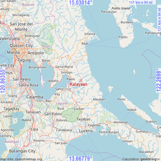
Kalayaan GPS coordinates[2]
14° 21' 0" North, 121° 34' 0.012" East
| Map corner | latitude | longitude |
|---|---|---|
| Upper-left | 15.03014°, | 120.86355° |
| Center: | 14.35°, | 121.56667° |
| Lower-right: | 13.66779°, | 122.2698° |
| Map W x H: | 151.5×151.5 km | = 94.1×94.1mi |
| max Lat: | 20.78733° ⇑26.7% North |
| Kalayaan: | 14.35° |
| min Lat: | ⇓73.3% South 4.65442° |
| min Long | Kalayaan | max Long |
| 117.04868° | 121.56667° | 126.58417° |
| W 34.3%⇐ | ⇒65.7% E |
Elevation
Elevation of Kalayaan is 391 m = 1283 ft, and this is 303.1 m = 994 ft above average elevation for this country.
| Max E: |
2262 m = 7421 ft | 5.4% |
| Kalayaan | 391 m 1283 ft | |
| Avg. | 87.9 m = 288 ft | |
Min E: |
-2 m = -7 ft | 94.6% |
See also: Philippines elevation on elevation.city.
Geographical zone
Kalayaan is located in North Torrid zone (between Equator and Tropic of Cancer). Distance of this Northern Tropic circle is 1010.3 km =627.8 mi to North.| Distance of | km | miles | from Kalayaan |
|---|---|---|---|
| North Pole | 8411.5 | 5226.7 | to North |
| Arctic Circle | 5805.6 | 3607.4 | to North |
| Tropic Cancer | 1010.3 | 627.8 | to North |
| Equator | 1595.6 | 991.5 | to South |


Nearby cities:
15 places around Kalayaan: (largest is in red/bold)
• Cavinti
13.3 km =8.3 mi,  208°
208°
• Famy
16.1 km =10 mi,  307°
307°
• Kabulusan
18 km =11.2 mi,  274°
274°
• Kapatalan
16.1 km =10 mi,  329°
329°
• Lumbang
12.9 km =8 mi,  243°
243°
• Mabitac
17.1 km =10.6 mi,  299°
299°
• Maulawin
17.1 km =10.6 mi, 237°
• Paete
9.2 km =5.7 mi,  280°
280°
• Pagsanjan
14.7 km =9.1 mi,  234°
234°
• Pakil
10.2 km =6.3 mi,  291°
291°
• Pangil
12.4 km =7.7 mi, 298°
• San Antonio
18.2 km =11.3 mi,  203°
203°
• Santa Cruz
17.9 km =11.1 mi, 244°
• Siniloan
15.2 km =9.4 mi, 301°
• Wawa
12.7 km =7.9 mi,  245°
245°
Sources, notices
• [Note1] Compared only with cities in Philippines existing in our database
• [Src1] Map data: © OpenStreetMap contributors (CC-BY-SA)
• [Src2] Other city data from geonames.org with taken over terms of usage.
• [Src3] Geographical zone / Annual Mean Temperature by Robert A. Rohde @ Wikipedia
