Maulawin geodata
Maulawin (Calabarzon) is a populated place; located in Philippines in Asia/Manila (GMT+8) time zone. With population of 6,822 people, there are 917 cities with bigger population in this country. Compared to other cities in Philippines, 72.5% of cities are located further ↓South; 67.9% of cities are located further →East and 80.7% of cities have higher elevation than Maulawin. Note1


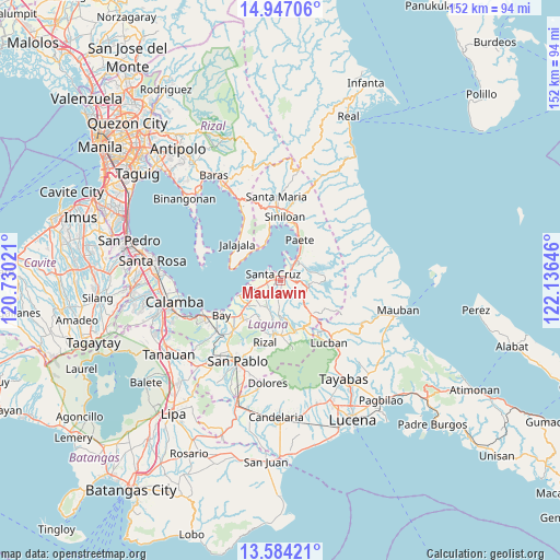
Maulawin GPS coordinates[2]
14° 16' 0.012" North, 121° 25' 59.988" East
| Map corner | latitude | longitude |
|---|---|---|
| Upper-left | 14.94706°, | 120.73021° |
| Center: | 14.26667°, | 121.43333° |
| Lower-right: | 13.58421°, | 122.13646° |
| Map W x H: | 151.5×151.5 km | = 94.1×94.1mi |
| max Lat: | 20.78733° ⇑27.5% North |
| Maulawin: | 14.26667° |
| min Lat: | ⇓72.5% South 4.65442° |
| min Long | Maulawin | max Long |
| 117.04868° | 121.43333° | 126.58417° |
| W 32.1%⇐ | ⇒67.9% E |
Elevation
Elevation of Maulawin is 9 m = 30 ft, and this is 78.9 m = 259 ft below average elevation for this country.
| Max E: |
2262 m = 7421 ft | 80.7% |
| Avg. | 87.9 m = 288 ft | |
| Maulawin | 9 m = 30 ft | |
Min E: |
-2 m = -7 ft | 19.3% |
See also: Philippines elevation on elevation.city.
Geographical zone
Maulawin is located in North Torrid zone (between Equator and Tropic of Cancer). Distance of this Northern Tropic circle is 1019.6 km =633.5 mi to North.| Distance of | km | miles | from Maulawin |
|---|---|---|---|
| North Pole | 8420.8 | 5232.4 | to North |
| Arctic Circle | 5814.9 | 3613.2 | to North |
| Tropic Cancer | 1019.6 | 633.5 | to North |
| Equator | 1586.3 | 985.7 | to South |


Nearby cities:
15 places around Maulawin: (largest is in red/bold)
• Bagombong
10.2 km =6.3 mi,  324°
324°
• Cabanbanan
2.9 km =1.8 mi,  178°
178°
• Calumpang
8.5 km =5.3 mi,  203°
203°
• Cavinti
8.4 km =5.2 mi,  106°
106°
• Cigaras
4.5 km =2.8 mi, 184°
• Halayhayin
9.1 km =5.7 mi, 197°
• Lumbang
4.4 km =2.7 mi,  39°
39°
• Magdalena
7.4 km =4.6 mi, 183°
• Pagsanjan
2.5 km =1.6 mi,  72°
72°
• Pila
8.3 km =5.2 mi,  242°
242°
• San Antonio
10.3 km =6.4 mi,  135°
135°
• San Isidro
7.5 km =4.7 mi,  210°
210°
• San Miguel
9.7 km =6 mi,  221°
221°
• Santa Cruz
2.5 km =1.6 mi,  311°
311°
• Wawa
4.8 km =3 mi, 35°
Sources, notices
• [Note1] Compared only with cities in Philippines existing in our database
• [Src1] Map data: © OpenStreetMap contributors (CC-BY-SA)
• [Src2] Other city data from geonames.org with taken over terms of usage.
• [Src3] Geographical zone / Annual Mean Temperature by Robert A. Rohde @ Wikipedia
