Santa Cruz geodata
Santa Cruz (Calabarzon) is a seat of a third-order administrative division; located in Philippines in Asia/Manila (GMT+8) time zone. With population of 108,145 people, there are 86 cities with bigger population in this country. Compared to other cities in Philippines, 72.7% of cities are located further ↓South; 68.3% of cities are located further →East and 80.7% of cities have higher elevation than Santa Cruz. Note1


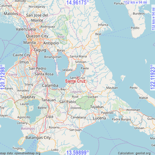
Santa Cruz GPS coordinates[2]
14° 16' 53.04" North, 121° 24' 57.96" East
| Map corner | latitude | longitude |
|---|---|---|
| Upper-left | 14.96175°, | 120.71298° |
| Center: | 14.2814°, | 121.4161° |
| Lower-right: | 13.59899°, | 122.11923° |
| Map W x H: | 151.5×151.5 km | = 94.1×94.1mi |
| max Lat: | 20.78733° ⇑27.3% North |
| Santa Cruz: | 14.2814° |
| min Lat: | ⇓72.7% South 4.65442° |
| min Long | Santa Cruz | max Long |
| 117.04868° | 121.4161° | 126.58417° |
| W 31.7%⇐ | ⇒68.3% E |
Elevation
Elevation of Santa Cruz is 9 m = 30 ft, and this is 78.9 m = 259 ft below average elevation for this country.
| Max E: |
2262 m = 7421 ft | 80.7% |
| Avg. | 87.9 m = 288 ft | |
| Santa Cruz | 9 m = 30 ft | |
Min E: |
-2 m = -7 ft | 19.3% |
See also: Santa Cruz elevation on elevation.city.
Geographical zone
Santa Cruz is located in North Torrid zone (between Equator and Tropic of Cancer). Distance of this Northern Tropic circle is 1018 km =632.6 mi to North.| Distance of | km | miles | from Santa Cruz |
|---|---|---|---|
| North Pole | 8419.1 | 5231.4 | to North |
| Arctic Circle | 5813.2 | 3612.2 | to North |
| Tropic Cancer | 1018 | 632.6 | to North |
| Equator | 1587.9 | 986.7 | to South |


Nearby cities:
15 places around Santa Cruz: (largest is in red/bold)
• Bagombong
7.9 km =4.9 mi,  328°
328°
• Cabanbanan
5 km =3.1 mi,  156°
156°
• Calumpang
9.6 km =6 mi,  189°
189°
• Cavinti
10.7 km =6.6 mi,  112°
112°
• Cigaras
6.3 km =3.9 mi,  166°
166°
• Halayhayin
10.3 km =6.4 mi, 185°
• Kabulusan
9.1 km =5.7 mi,  349°
349°
• Lumbang
5 km =3.1 mi,  69°
69°
• Magdalena
9.2 km =5.7 mi, 171°
• Maulawin
2.5 km =1.6 mi,  131°
131°
• Pagsanjan
4.3 km =2.7 mi,  102°
102°
• Pila
7.8 km =4.8 mi,  225°
225°
• San Isidro
8.3 km =5.2 mi, 193°
• San Miguel
10 km =6.2 mi,  207°
207°
• Wawa
5.2 km =3.2 mi,  64°
64°
Sources, notices
• [Note1] Compared only with cities in Philippines existing in our database
• [Src1] Map data: © OpenStreetMap contributors (CC-BY-SA)
• [Src2] Other city data from geonames.org with taken over terms of usage.
• [Src3] Geographical zone / Annual Mean Temperature by Robert A. Rohde @ Wikipedia
