Cavinti geodata
Cavinti (Calabarzon) is a seat of a third-order administrative division; located in Philippines in Asia/Manila (GMT+8) time zone. With population of 9,758 people, there are 625 cities with bigger population in this country. Compared to other cities in Philippines, 72.3% of cities are located further ↓South; 66.4% of cities are located further →East and 89.5% of cities have lower elevation than Cavinti. Note1


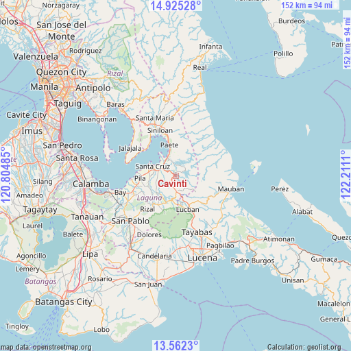
Cavinti GPS coordinates[2]
14° 14' 41.352" North, 121° 30' 28.692" East
| Map corner | latitude | longitude |
|---|---|---|
| Upper-left | 14.92528°, | 120.80485° |
| Center: | 14.24482°, | 121.50797° |
| Lower-right: | 13.5623°, | 122.2111° |
| Map W x H: | 151.5×151.6 km | = 94.1×94.2mi |
| max Lat: | 20.78733° ⇑27.7% North |
| Cavinti: | 14.24482° |
| min Lat: | ⇓72.3% South 4.65442° |
| min Long | Cavinti | max Long |
| 117.04868° | 121.50797° | 126.58417° |
| W 33.6%⇐ | ⇒66.4% E |
Elevation
Elevation of Cavinti is 219 m = 719 ft, and this is 131.1 m = 430 ft above average elevation for this country.
| Max E: |
2262 m = 7421 ft | 10.5% |
| Cavinti | 219 m 719 ft | |
| Avg. | 87.9 m = 288 ft | |
Min E: |
-2 m = -7 ft | 89.5% |
See also: Philippines elevation on elevation.city.
Geographical zone
Cavinti is located in North Torrid zone (between Equator and Tropic of Cancer). Distance of this Northern Tropic circle is 1022 km =635 mi to North.| Distance of | km | miles | from Cavinti |
|---|---|---|---|
| North Pole | 8423.2 | 5233.9 | to North |
| Arctic Circle | 5817.3 | 3614.7 | to North |
| Tropic Cancer | 1022 | 635 | to North |
| Equator | 1583.9 | 984.2 | to South |


Nearby cities:
15 places around Cavinti: (largest is in red/bold)
• Cabanbanan
8 km =5 mi,  266°
266°
• Cigaras
8.7 km =5.4 mi,  256°
256°
• Halayhayin
12.5 km =7.8 mi,  240°
240°
• Luisiana
6.7 km =4.2 mi,  177°
177°
• Lumbang
7.8 km =4.8 mi,  318°
318°
• Magdalena
9.9 km =6.2 mi, 239°
• Majayjay
11.6 km =7.2 mi,  199°
199°
• Maulawin
8.4 km =5.2 mi,  286°
286°
• Pagsanjan
6.5 km =4 mi,  299°
299°
• San Antonio
5.1 km =3.2 mi,  189°
189°
• San Diego
6.8 km =4.2 mi, 199°
• San Isidro
12.5 km =7.8 mi,  251°
251°
• Santa Cruz
10.7 km =6.6 mi, 292°
• Santo Tomas
6.9 km =4.3 mi, 187°
• Wawa
8.2 km =5.1 mi, 320°
Sources, notices
• [Note1] Compared only with cities in Philippines existing in our database
• [Src1] Map data: © OpenStreetMap contributors (CC-BY-SA)
• [Src2] Other city data from geonames.org with taken over terms of usage.
• [Src3] Geographical zone / Annual Mean Temperature by Robert A. Rohde @ Wikipedia
