Kabasalan geodata
Kabasalan (Autonomous Region in Muslim Mindanao) is a populated place; located in Philippines in Asia/Manila (GMT+8) time zone. With population of 2,190 people, there are 3905 cities with bigger population in this country. Compared to other cities in Philippines, 91% of cities are located further ↑North; 81.7% of cities are located further ←West and 85.4% of cities have higher elevation than Kabasalan. Note1
Administrative division(s):
- Level 1: Autonomous Region in Muslim Mindanao
- Level 2: Province of Maguindanao


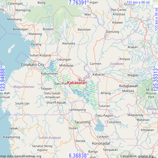
Kabasalan GPS coordinates[2]
7° 4' 0.012" North, 124° 39' 0" East
| Map corner | latitude | longitude |
|---|---|---|
| Upper-left | 7.76391°, | 123.94688° |
| Center: | 7.06667°, | 124.65° |
| Lower-right: | 6.36838°, | 125.35313° |
| Map W x H: | 155.2×155.2 km | = 96.4×96.4mi |
| max Lat: | 20.78733° ⇑91% North |
| Kabasalan: | 7.06667° |
| min Lat: | ⇓9% South 4.65442° |
| min Long | Kabasalan | max Long |
| 117.04868° | 124.65° | 126.58417° |
| W 81.7%⇐ | ⇒18.3% E |
Elevation
Elevation of Kabasalan is 8 m = 26 ft, and this is 79.9 m = 262 ft below average elevation for this country.
| Max E: |
2262 m = 7421 ft | 85.4% |
| Avg. | 87.9 m = 288 ft | |
| Kabasalan | 8 m = 26 ft | |
Min E: |
-2 m = -7 ft | 14.6% |
See also: Philippines elevation on elevation.city.
Geographical zone
Kabasalan is located in North Torrid zone (between Equator and Tropic of Cancer). Distance of Equator is 785.7 km =488.2 mi to South.| Distance of | km | miles | from Kabasalan |
|---|---|---|---|
| North Pole | 9221.3 | 5729.8 | to North |
| Arctic Circle | 6615.4 | 4110.6 | to North |
| Tropic Cancer | 1820.2 | 1131 | to North |
| Equator | 785.7 | 488.2 | to South |


Nearby cities:
15 places around Kabasalan: (largest is in red/bold)
• Buliok
7.8 km =4.8 mi,  135°
135°
• Dualing
13.1 km =8.1 mi,  316°
316°
• Gocoton
10.9 km =6.8 mi,  24°
24°
• Kalbugan
11.9 km =7.4 mi,  175°
175°
• Layog
9 km =5.6 mi,  82°
82°
• Manaulanan
4 km =2.5 mi,  238°
238°
• Nunguan
8.1 km =5 mi,  32°
32°
• Pagalungan
5.7 km =3.5 mi,  101°
101°
• Pagangan
8 km =5 mi,  311°
311°
• Pikit
2.8 km =1.7 mi,  119°
119°
• Punolu
7.6 km =4.7 mi,  255°
255°
• Talitay
6.6 km =4.1 mi, 123°
• Tinutulan
3.7 km =2.3 mi,  0°
0°
• Tungol
11.5 km =7.1 mi, 82°
• Upper San Mateo
14 km =8.7 mi,  327°
327°
Sources, notices
• [Note1] Compared only with cities in Philippines existing in our database
• [Src1] Map data: © OpenStreetMap contributors (CC-BY-SA)
• [Src2] Other city data from geonames.org with taken over terms of usage.
• [Src3] Geographical zone / Annual Mean Temperature by Robert A. Rohde @ Wikipedia
