Punolu geodata
Punolu (Soccsksargen) is a populated place; located in Philippines in Asia/Manila (GMT+8) time zone. With population of 2,468 people, there are 3349 cities with bigger population in this country. Compared to other cities in Philippines, 91.2% of cities are located further ↑North; 80.4% of cities are located further ←West and 80.7% of cities have higher elevation than Punolu. Note1


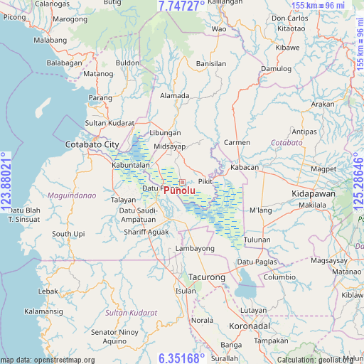
Punolu GPS coordinates[2]
7° 3' 0" North, 124° 34' 59.988" East
| Map corner | latitude | longitude |
|---|---|---|
| Upper-left | 7.74727°, | 123.88021° |
| Center: | 7.05°, | 124.58333° |
| Lower-right: | 6.35168°, | 125.28646° |
| Map W x H: | 155.2×155.2 km | = 96.4×96.4mi |
| max Lat: | 20.78733° ⇑91.2% North |
| Punolu: | 7.05° |
| min Lat: | ⇓8.8% South 4.65442° |
| min Long | Punolu | max Long |
| 117.04868° | 124.58333° | 126.58417° |
| W 80.4%⇐ | ⇒19.6% E |
Elevation
Elevation of Punolu is 9 m = 30 ft, and this is 78.9 m = 259 ft below average elevation for this country.
| Max E: |
2262 m = 7421 ft | 80.7% |
| Avg. | 87.9 m = 288 ft | |
| Punolu | 9 m = 30 ft | |
Min E: |
-2 m = -7 ft | 19.3% |
See also: Philippines elevation on elevation.city.
Geographical zone
Punolu is located in North Torrid zone (between Equator and Tropic of Cancer). Distance of Equator is 783.9 km =487.1 mi to South.| Distance of | km | miles | from Punolu |
|---|---|---|---|
| North Pole | 9223.2 | 5731 | to North |
| Arctic Circle | 6617.3 | 4111.8 | to North |
| Tropic Cancer | 1822 | 1132.1 | to North |
| Equator | 783.9 | 487.1 | to South |


Nearby cities:
15 places around Punolu: (largest is in red/bold)
• Buliok
13.4 km =8.3 mi,  106°
106°
• Damabalas
8.5 km =5.3 mi,  243°
243°
• Damatulan
11.2 km =7 mi,  263°
263°
• Datu Piang
9.2 km =5.7 mi,  254°
254°
• Dualing
11.4 km =7.1 mi,  351°
351°
• Glad
13.1 km =8.1 mi,  326°
326°
• Kabasalan
7.6 km =4.7 mi,  75°
75°
• Kalbugan
13.1 km =8.1 mi,  140°
140°
• Manaulanan
4 km =2.5 mi,  93°
93°
• Pagalungan
13 km =8.1 mi, 86°
• Pagangan
7.3 km =4.5 mi,  10°
10°
• Pidsandawan
13.1 km =8.1 mi,  176°
176°
• Pikit
9.8 km =6.1 mi, 87°
• Talitay
13 km =8.1 mi,  98°
98°
• Tinutulan
9.2 km =5.7 mi,  52°
52°
Sources, notices
• [Note1] Compared only with cities in Philippines existing in our database
• [Src1] Map data: © OpenStreetMap contributors (CC-BY-SA)
• [Src2] Other city data from geonames.org with taken over terms of usage.
• [Src3] Geographical zone / Annual Mean Temperature by Robert A. Rohde @ Wikipedia
