Kalbugan geodata
Kalbugan (Autonomous Region in Muslim Mindanao) is a populated place; located in Philippines in Asia/Manila (GMT+8) time zone. With population of 3,226 people, there are 2280 cities with bigger population in this country. Compared to other cities in Philippines, 92.1% of cities are located further ↑North; 81.8% of cities are located further ←West and 65.1% of cities have higher elevation than Kalbugan. Note1
Administrative division(s):
- Level 1: Autonomous Region in Muslim Mindanao
- Level 2: Province of Maguindanao


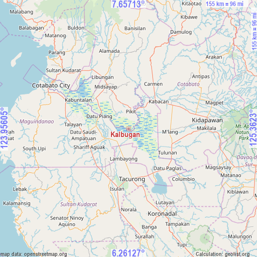
Kalbugan GPS coordinates[2]
6° 57' 34.992" North, 124° 39' 33.012" East
| Map corner | latitude | longitude |
|---|---|---|
| Upper-left | 7.65713°, | 123.95605° |
| Center: | 6.95972°, | 124.65917° |
| Lower-right: | 6.26127°, | 125.3623° |
| Map W x H: | 155.2×155.2 km | = 96.4×96.4mi |
| max Lat: | 20.78733° ⇑92.1% North |
| Kalbugan: | 6.95972° |
| min Lat: | ⇓7.9% South 4.65442° |
| min Long | Kalbugan | max Long |
| 117.04868° | 124.65917° | 126.58417° |
| W 81.8%⇐ | ⇒18.2% E |
Elevation
Elevation of Kalbugan is 14 m = 46 ft, and this is 73.9 m = 242 ft below average elevation for this country.
| Max E: |
2262 m = 7421 ft | 65.1% |
| Avg. | 87.9 m = 288 ft | |
| Kalbugan | 14 m = 46 ft | |
Min E: |
-2 m = -7 ft | 34.9% |
See also: Philippines elevation on elevation.city.
Geographical zone
Kalbugan is located in North Torrid zone (between Equator and Tropic of Cancer). Distance of Equator is 773.8 km =480.8 mi to South.| Distance of | km | miles | from Kalbugan |
|---|---|---|---|
| North Pole | 9233.2 | 5737.2 | to North |
| Arctic Circle | 6627.3 | 4118 | to North |
| Tropic Cancer | 1832.1 | 1138.4 | to North |
| Equator | 773.8 | 480.8 | to South |


Nearby cities:
15 places around Kalbugan: (largest is in red/bold)
• Badak
14.2 km =8.8 mi,  151°
151°
• Barurao
9.7 km =6 mi,  224°
224°
• Buliok
7.8 km =4.8 mi,  35°
35°
• Kabasalan
11.9 km =7.4 mi,  355°
355°
• Manaulanan
10.8 km =6.7 mi,  335°
335°
• Mileb
10.7 km =6.6 mi,  230°
230°
• Pagalungan
11.7 km =7.3 mi,  23°
23°
• Panadtaban
6.8 km =4.2 mi,  195°
195°
• Pidsandawan
8.1 km =5 mi,  247°
247°
• Pikit
10.6 km =6.6 mi,  7°
7°
• Pimbalayan
10.2 km =6.3 mi,  171°
171°
• Punolu
13.1 km =8.1 mi,  320°
320°
• Sambuluan
9.6 km =6 mi, 152°
• Sampao
11.6 km =7.2 mi, 217°
• Talitay
9.3 km =5.8 mi,  28°
28°
Sources, notices
• [Note1] Compared only with cities in Philippines existing in our database
• [Src1] Map data: © OpenStreetMap contributors (CC-BY-SA)
• [Src2] Other city data from geonames.org with taken over terms of usage.
• [Src3] Geographical zone / Annual Mean Temperature by Robert A. Rohde @ Wikipedia
