Josefina geodata
Josefina (Zamboanga Peninsula) is a populated place; located in Philippines in Asia/Manila (GMT+8) time zone. With population of 3,152 people, there are 2353 cities with bigger population in this country. Compared to other cities in Philippines, 80.7% of cities are located further ↑North; 62.9% of cities are located further ←West and 96.4% of cities have lower elevation than Josefina. Note1
Administrative division(s):
- Level 1: Zamboanga Peninsula
- Level 2: Province of Zamboanga del Sur
- Level 3: Josefina


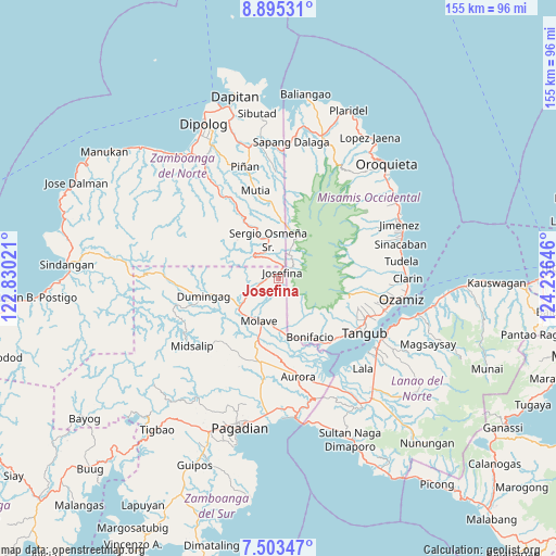
Josefina GPS coordinates[2]
8° 12' 0" North, 123° 31' 59.988" East
| Map corner | latitude | longitude |
|---|---|---|
| Upper-left | 8.89531°, | 122.83021° |
| Center: | 8.2°, | 123.53333° |
| Lower-right: | 7.50347°, | 124.23646° |
| Map W x H: | 154.8×154.8 km | = 96.2×96.2mi |
| max Lat: | 20.78733° ⇑80.7% North |
| Josefina: | 8.2° |
| min Lat: | ⇓19.3% South 4.65442° |
| min Long | Josefina | max Long |
| 117.04868° | 123.53333° | 126.58417° |
| W 62.9%⇐ | ⇒37.1% E |
Elevation
Elevation of Josefina is 539 m = 1768 ft, and this is 451.1 m = 1480 ft above average elevation for this country.
| Max E: |
2262 m = 7421 ft | 3.6% |
| Josefina | 539 m 1768 ft | |
| Avg. | 87.9 m = 288 ft | |
Min E: |
-2 m = -7 ft | 96.4% |
See also: Philippines elevation on elevation.city.
Geographical zone
Josefina is located in North Torrid zone (between Equator and Tropic of Cancer). Distance of Equator is 911.8 km =566.6 mi to South.| Distance of | km | miles | from Josefina |
|---|---|---|---|
| North Pole | 9095.3 | 5651.6 | to North |
| Arctic Circle | 6489.4 | 4032.3 | to North |
| Tropic Cancer | 1694.2 | 1052.7 | to North |
| Equator | 911.8 | 566.6 | to South |


Nearby cities:
15 places around Josefina: (largest is in red/bold)
• Aurora
28.3 km =17.6 mi,  168°
168°
• Bonifacio
18.7 km =11.6 mi,  151°
151°
• Dimaluna
30.6 km =19 mi,  106°
106°
• Dumingag
20.4 km =12.7 mi,  260°
260°
• Gubaan
25.3 km =15.7 mi, 172°
• Mahayag
13.3 km =8.3 mi,  226°
226°
• Molave
13.7 km =8.5 mi,  199°
199°
• Pangabuan
23.9 km =14.9 mi,  131°
131°
• Ramon Magsaysay
22.2 km =13.8 mi,  186°
186°
• Sergio Osmeña Sr
5.2 km =3.2 mi,  224°
224°
• Sumalig
26.5 km =16.5 mi, 147°
• Tabid
29 km =18 mi, 110°
• Tambulig
14.4 km =8.9 mi,  179°
179°
• Tangub
28.2 km =17.5 mi,  123°
123°
• Tiparak
18.5 km =11.5 mi, 181°
Sources, notices
• [Note1] Compared only with cities in Philippines existing in our database
• [Src1] Map data: © OpenStreetMap contributors (CC-BY-SA)
• [Src2] Other city data from geonames.org with taken over terms of usage.
• [Src3] Geographical zone / Annual Mean Temperature by Robert A. Rohde @ Wikipedia
