Molave geodata
Molave (Zamboanga Peninsula) is a populated place; located in Philippines in Asia/Manila (GMT+8) time zone. With population of 21,088 people, there are 359 cities with bigger population in this country. Compared to other cities in Philippines, 81.7% of cities are located further ↑North; 62% of cities are located further ←West and 57.6% of cities have higher elevation than Molave. Note1
Administrative division(s):
- Level 1: Zamboanga Peninsula
- Level 2: Province of Zamboanga del Sur
- Level 3: Molave


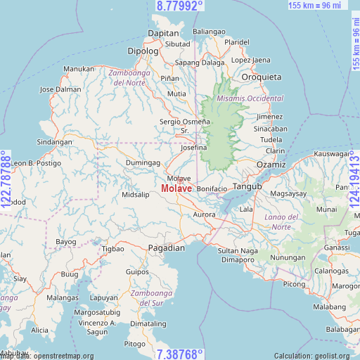
Molave GPS coordinates[2]
8° 5' 3.84" North, 123° 29' 27.6" East
| Map corner | latitude | longitude |
|---|---|---|
| Upper-left | 8.77992°, | 122.78788° |
| Center: | 8.0844°, | 123.491° |
| Lower-right: | 7.38768°, | 124.19413° |
| Map W x H: | 154.8×154.8 km | = 96.2×96.2mi |
| max Lat: | 20.78733° ⇑81.7% North |
| Molave: | 8.0844° |
| min Lat: | ⇓18.3% South 4.65442° |
| min Long | Molave | max Long |
| 117.04868° | 123.491° | 126.58417° |
| W 62%⇐ | ⇒38% E |
Elevation
Elevation of Molave is 18 m = 59 ft, and this is 69.9 m = 229 ft below average elevation for this country.
| Max E: |
2262 m = 7421 ft | 57.6% |
| Avg. | 87.9 m = 288 ft | |
| Molave | 18 m = 59 ft | |
Min E: |
-2 m = -7 ft | 42.4% |
See also: Philippines elevation on elevation.city.
Geographical zone
Molave is located in North Torrid zone (between Equator and Tropic of Cancer). Distance of Equator is 898.9 km =558.6 mi to South.| Distance of | km | miles | from Molave |
|---|---|---|---|
| North Pole | 9108.2 | 5659.6 | to North |
| Arctic Circle | 6502.3 | 4040.3 | to North |
| Tropic Cancer | 1707 | 1060.7 | to North |
| Equator | 898.9 | 558.6 | to South |


Nearby cities:
15 places around Molave: (largest is in red/bold)
• Aurora
18 km =11.2 mi,  145°
145°
• Bonifacio
14 km =8.7 mi,  104°
104°
• Dumingag
18.1 km =11.2 mi,  301°
301°
• Gubaan
14.6 km =9.1 mi, 146°
• Josefina
13.7 km =8.5 mi,  19°
19°
• Labangan
24.5 km =15.2 mi,  174°
174°
• Mahayag
6.3 km =3.9 mi,  306°
306°
• Margos
25.1 km =15.6 mi,  132°
132°
• Pangabuan
22.8 km =14.2 mi, 97°
• Ramon Magsaysay
9.4 km =5.8 mi, 167°
• Sergio Osmeña Sr
9.2 km =5.7 mi,  6°
6°
• Sumalig
21.2 km =13.2 mi,  116°
116°
• Taguitic
22.4 km =13.9 mi,  136°
136°
• Tambulig
5.1 km =3.2 mi,  108°
108°
• Tiparak
7 km =4.3 mi, 143°
Sources, notices
• [Note1] Compared only with cities in Philippines existing in our database
• [Src1] Map data: © OpenStreetMap contributors (CC-BY-SA)
• [Src2] Other city data from geonames.org with taken over terms of usage.
• [Src3] Geographical zone / Annual Mean Temperature by Robert A. Rohde @ Wikipedia
