Infanta geodata
Infanta (Ilocos) is a populated place; located in Philippines in Asia/Manila (GMT+8) time zone. With population of 3,161 people, there are 2340 cities with bigger population in this country. Compared to other cities in Philippines, 85.2% of cities are located further ↓South; 97.9% of cities are located further →East and 89.7% of cities have higher elevation than Infanta. Note1


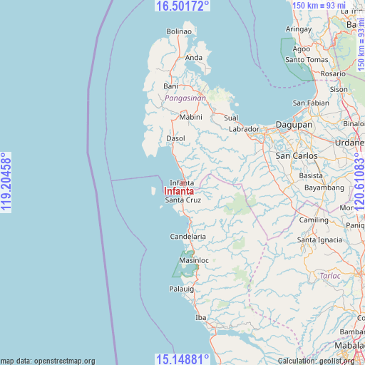
Infanta GPS coordinates[2]
15° 49' 35.04" North, 119° 54' 27.72" East
| Map corner | latitude | longitude |
|---|---|---|
| Upper-left | 16.50172°, | 119.20458° |
| Center: | 15.8264°, | 119.9077° |
| Lower-right: | 15.14881°, | 120.61083° |
| Map W x H: | 150.4×150.4 km | = 93.5×93.5mi |
| max Lat: | 20.78733° ⇑14.8% North |
| Infanta: | 15.8264° |
| min Lat: | ⇓85.2% South 4.65442° |
| min Long | Infanta | max Long |
| 117.04868° | 119.9077° | 126.58417° |
| W 2.1%⇐ | ⇒97.9% E |
Elevation
Elevation of Infanta is 7 m = 23 ft, and this is 80.9 m = 265 ft below average elevation for this country.
| Max E: |
2262 m = 7421 ft | 89.7% |
| Avg. | 87.9 m = 288 ft | |
| Infanta | 7 m = 23 ft | |
Min E: |
-2 m = -7 ft | 10.3% |
See also: Philippines elevation on elevation.city.
Geographical zone
Infanta is located in North Torrid zone (between Equator and Tropic of Cancer). Distance of this Northern Tropic circle is 846.2 km =525.8 mi to North.| Distance of | km | miles | from Infanta |
|---|---|---|---|
| North Pole | 8247.3 | 5124.6 | to North |
| Arctic Circle | 5641.4 | 3505.4 | to North |
| Tropic Cancer | 846.2 | 525.8 | to North |
| Equator | 1759.7 | 1093.4 | to South |


Nearby cities:
15 places around Infanta: (largest is in red/bold)
• Bani
27.3 km =17 mi,  174°
174°
• Biay
9.6 km =6 mi,  180°
180°
• Bolitoc
10.2 km =6.3 mi,  198°
198°
• Burgos
26.2 km =16.3 mi,  349°
349°
• Cato
1.3 km =0.8 mi,  35°
35°
• Dasol
18.4 km =11.4 mi, 351°
• Eguia
9.2 km =5.7 mi, 345°
• Guisguis
8.3 km =5.2 mi,  116°
116°
• Ilioilio
21.4 km =13.3 mi,  314°
314°
• Lucapon
14.3 km =8.9 mi, 169°
• Mabini
27.3 km =17 mi,  7°
7°
• Malabon
21.4 km =13.3 mi, 171°
• Santa Cruz
6.8 km =4.2 mi, 178°
• Taltal
26.8 km =16.7 mi, 171°
• Uacon
16.8 km =10.4 mi, 168°
Sources, notices
• [Note1] Compared only with cities in Philippines existing in our database
• [Src1] Map data: © OpenStreetMap contributors (CC-BY-SA)
• [Src2] Other city data from geonames.org with taken over terms of usage.
• [Src3] Geographical zone / Annual Mean Temperature by Robert A. Rohde @ Wikipedia
