Cato geodata
Cato (Ilocos) is a populated place; located in Philippines in Asia/Manila (GMT+8) time zone. With population of 4,529 people, there are 1477 cities with bigger population in this country. Compared to other cities in Philippines, 85.3% of cities are located further ↓South; 97.8% of cities are located further →East and 92.7% of cities have higher elevation than Cato. Note1


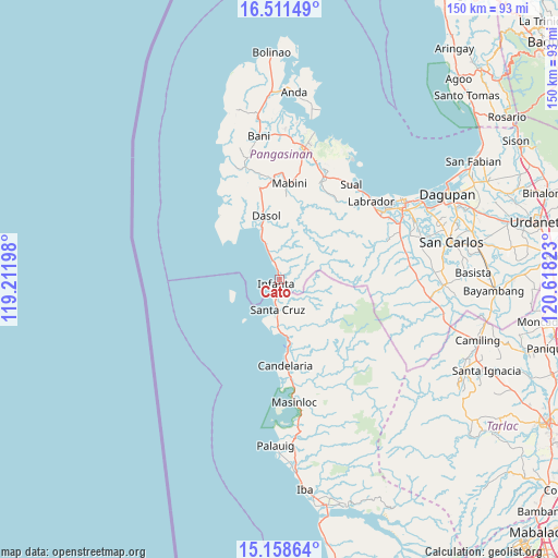
Cato GPS coordinates[2]
15° 50' 10.32" North, 119° 54' 54.36" East
| Map corner | latitude | longitude |
|---|---|---|
| Upper-left | 16.51149°, | 119.21198° |
| Center: | 15.8362°, | 119.9151° |
| Lower-right: | 15.15864°, | 120.61823° |
| Map W x H: | 150.4×150.4 km | = 93.5×93.5mi |
| max Lat: | 20.78733° ⇑14.7% North |
| Cato: | 15.8362° |
| min Lat: | ⇓85.3% South 4.65442° |
| min Long | Cato | max Long |
| 117.04868° | 119.9151° | 126.58417° |
| W 2.2%⇐ | ⇒97.8% E |
Elevation
Elevation of Cato is 6 m = 20 ft, and this is 81.9 m = 269 ft below average elevation for this country.
| Max E: |
2262 m = 7421 ft | 92.7% |
| Avg. | 87.9 m = 288 ft | |
| Cato | 6 m = 20 ft | |
Min E: |
-2 m = -7 ft | 7.3% |
See also: Philippines elevation on elevation.city.
Geographical zone
Cato is located in North Torrid zone (between Equator and Tropic of Cancer). Distance of this Northern Tropic circle is 845.1 km =525.1 mi to North.| Distance of | km | miles | from Cato |
|---|---|---|---|
| North Pole | 8246.2 | 5123.9 | to North |
| Arctic Circle | 5640.4 | 3504.8 | to North |
| Tropic Cancer | 845.1 | 525.1 | to North |
| Equator | 1760.8 | 1094.1 | to South |


Nearby cities:
15 places around Cato: (largest is in red/bold)
• Biay
10.7 km =6.6 mi,  184°
184°
• Bolitoc
11.5 km =7.1 mi,  200°
200°
• Burgos
25.3 km =15.7 mi,  347°
347°
• Dasol
17.5 km =10.9 mi, 348°
• Eguia
8.4 km =5.2 mi,  338°
338°
• Guisguis
8.2 km =5.1 mi,  126°
126°
• Ilioilio
21.2 km =13.2 mi,  311°
311°
• Infanta
1.3 km =0.8 mi,  215°
215°
• Lucapon
15.3 km =9.5 mi,  173°
173°
• Mabini
26.1 km =16.2 mi,  5°
5°
• Malabon
22.4 km =13.9 mi, 173°
• Santa Cruz
7.9 km =4.9 mi, 184°
• Tagudin
27.5 km =17.1 mi, 8°
• Taltal
27.8 km =17.3 mi, 173°
• Uacon
17.7 km =11 mi, 171°
Sources, notices
• [Note1] Compared only with cities in Philippines existing in our database
• [Src1] Map data: © OpenStreetMap contributors (CC-BY-SA)
• [Src2] Other city data from geonames.org with taken over terms of usage.
• [Src3] Geographical zone / Annual Mean Temperature by Robert A. Rohde @ Wikipedia
