Ichon geodata
Ichon (Eastern Visayas) is a populated place; located in Philippines in Asia/Manila (GMT+8) time zone. With population of 3,821 people, there are 1830 cities with bigger population in this country. Compared to other cities in Philippines, 67.5% of cities are located further ↑North; 86.3% of cities are located further ←West and 59.2% of cities have higher elevation than Ichon. Note1
Administrative division(s):
- Level 1: Eastern Visayas
- Level 2: Province of Southern Leyte
- Level 3: Macrohon


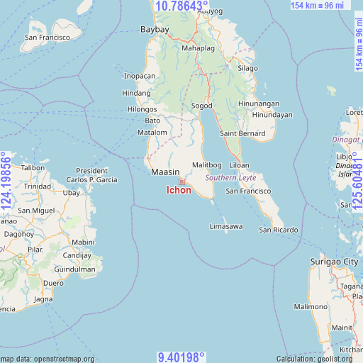
Ichon GPS coordinates[2]
10° 5' 41.82" North, 124° 54' 6.048" East
| Map corner | latitude | longitude |
|---|---|---|
| Upper-left | 10.78643°, | 124.19856° |
| Center: | 10.09495°, | 124.90168° |
| Lower-right: | 9.40198°, | 125.60481° |
| Map W x H: | 153.9×153.9 km | = 95.6×95.6mi |
| max Lat: | 20.78733° ⇑67.5% North |
| Ichon: | 10.09495° |
| min Lat: | ⇓32.5% South 4.65442° |
| min Long | Ichon | max Long |
| 117.04868° | 124.90168° | 126.58417° |
| W 86.3%⇐ | ⇒13.7% E |
Elevation
Elevation of Ichon is 17 m = 56 ft, and this is 70.9 m = 233 ft below average elevation for this country.
| Max E: |
2262 m = 7421 ft | 59.2% |
| Avg. | 87.9 m = 288 ft | |
| Ichon | 17 m = 56 ft | |
Min E: |
-2 m = -7 ft | 40.8% |
See also: Philippines elevation on elevation.city.
Geographical zone
Ichon is located in North Torrid zone (between Equator and Tropic of Cancer). Distance of Equator is 1122.5 km =697.5 mi to South.| Distance of | km | miles | from Ichon |
|---|---|---|---|
| North Pole | 8884.6 | 5520.6 | to North |
| Arctic Circle | 6278.7 | 3901.4 | to North |
| Tropic Cancer | 1483.5 | 921.8 | to North |
| Equator | 1122.5 | 697.5 | to South |


Nearby cities:
15 places around Ichon: (largest is in red/bold)
• Anahawan
27.7 km =17.2 mi,  354°
354°
• Bato
28.6 km =17.8 mi,  334°
334°
• Ibarra
3.8 km =2.4 mi, 329°
• Libagon
28.4 km =17.6 mi,  36°
36°
• Liloan
24.7 km =15.3 mi,  73°
73°
• Maasin
7.6 km =4.7 mi,  304°
304°
• Macrohon
4.8 km =3 mi,  110°
110°
• Malitbog
12.9 km =8 mi,  55°
55°
• Matalom
24.3 km =15.1 mi, 329°
• Padre Burgos
14.4 km =8.9 mi,  116°
116°
• Pasay
2.3 km =1.4 mi,  342°
342°
• San Francisco
28.6 km =17.8 mi,  97°
97°
• Santa Fe
21.3 km =13.2 mi,  318°
318°
• Santa Paz
23.1 km =14.4 mi, 325°
• Tomas Oppus
19.5 km =12.1 mi,  27°
27°
Sources, notices
• [Note1] Compared only with cities in Philippines existing in our database
• [Src1] Map data: © OpenStreetMap contributors (CC-BY-SA)
• [Src2] Other city data from geonames.org with taken over terms of usage.
• [Src3] Geographical zone / Annual Mean Temperature by Robert A. Rohde @ Wikipedia
