Ibarra geodata
Ibarra (Eastern Visayas) is a populated place; located in Philippines in Asia/Manila (GMT+8) time zone. With population of 3,065 people, there are 2452 cities with bigger population in this country. Compared to other cities in Philippines, 67.1% of cities are located further ↑North; 85.9% of cities are located further ←West and 89.7% of cities have higher elevation than Ibarra. Note1
Administrative division(s):
- Level 1: Eastern Visayas
- Level 2: Province of Southern Leyte
- Level 3: City of Maasin


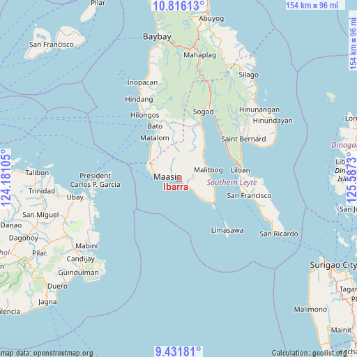
Ibarra GPS coordinates[2]
10° 7' 28.992" North, 124° 53' 3.012" East
| Map corner | latitude | longitude |
|---|---|---|
| Upper-left | 10.81613°, | 124.18105° |
| Center: | 10.12472°, | 124.88417° |
| Lower-right: | 9.43181°, | 125.5873° |
| Map W x H: | 153.9×153.9 km | = 95.6×95.6mi |
| max Lat: | 20.78733° ⇑67.1% North |
| Ibarra: | 10.12472° |
| min Lat: | ⇓32.9% South 4.65442° |
| min Long | Ibarra | max Long |
| 117.04868° | 124.88417° | 126.58417° |
| W 85.9%⇐ | ⇒14.1% E |
Elevation
Elevation of Ibarra is 7 m = 23 ft, and this is 80.9 m = 265 ft below average elevation for this country.
| Max E: |
2262 m = 7421 ft | 89.7% |
| Avg. | 87.9 m = 288 ft | |
| Ibarra | 7 m = 23 ft | |
Min E: |
-2 m = -7 ft | 10.3% |
See also: Philippines elevation on elevation.city.
Geographical zone
Ibarra is located in North Torrid zone (between Equator and Tropic of Cancer). Distance of Equator is 1125.8 km =699.5 mi to South.| Distance of | km | miles | from Ibarra |
|---|---|---|---|
| North Pole | 8881.3 | 5518.6 | to North |
| Arctic Circle | 6275.4 | 3899.4 | to North |
| Tropic Cancer | 1480.2 | 919.8 | to North |
| Equator | 1125.8 | 699.5 | to South |


Nearby cities:
15 places around Ibarra: (largest is in red/bold)
• Anahawan
24.3 km =15.1 mi,  358°
358°
• Bato
24.8 km =15.4 mi,  335°
335°
• Ichon
3.8 km =2.4 mi,  149°
149°
• Libagon
27.1 km =16.8 mi,  43°
43°
• Liloan
25.9 km =16.1 mi,  81°
81°
• Maasin
4.4 km =2.7 mi,  282°
282°
• Macrohon
8.2 km =5.1 mi,  127°
127°
• Malitbog
13.2 km =8.2 mi,  72°
72°
• Matalom
20.5 km =12.7 mi,  329°
329°
• Padre Burgos
17.7 km =11 mi,  123°
123°
• Pasay
1.7 km =1.1 mi, 132°
• Santa Fe
17.6 km =10.9 mi,  315°
315°
• Santa Paz
19.3 km =12 mi, 325°
• Tabonoc
26.7 km =16.6 mi, 339°
• Tomas Oppus
17.7 km =11 mi, 37°
Sources, notices
• [Note1] Compared only with cities in Philippines existing in our database
• [Src1] Map data: © OpenStreetMap contributors (CC-BY-SA)
• [Src2] Other city data from geonames.org with taken over terms of usage.
• [Src3] Geographical zone / Annual Mean Temperature by Robert A. Rohde @ Wikipedia
