Maloma geodata
Maloma (Central Luzon) is a populated place; located in Philippines in Asia/Manila (GMT+8) time zone. With population of 4,430 people, there are 1527 cities with bigger population in this country. Compared to other cities in Philippines, 78.6% of cities are located further ↓South; 96.8% of cities are located further →East and 65.1% of cities have higher elevation than Maloma. Note1
Administrative division(s):
- Level 1: Central Luzon
- Level 2: Province of Zambales
- Level 3: San Felipe


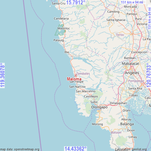
Maloma GPS coordinates[2]
15° 6' 48.6" North, 120° 3' 50.04" East
| Map corner | latitude | longitude |
|---|---|---|
| Upper-left | 15.7912°, | 119.36078° |
| Center: | 15.1135°, | 120.0639° |
| Lower-right: | 14.43362°, | 120.76703° |
| Map W x H: | 150.9×151 km | = 93.8×93.8mi |
| max Lat: | 20.78733° ⇑21.4% North |
| Maloma: | 15.1135° |
| min Lat: | ⇓78.6% South 4.65442° |
| min Long | Maloma | max Long |
| 117.04868° | 120.0639° | 126.58417° |
| W 3.2%⇐ | ⇒96.8% E |
Elevation
Elevation of Maloma is 14 m = 46 ft, and this is 73.9 m = 242 ft below average elevation for this country.
| Max E: |
2262 m = 7421 ft | 65.1% |
| Avg. | 87.9 m = 288 ft | |
| Maloma | 14 m = 46 ft | |
Min E: |
-2 m = -7 ft | 34.9% |
See also: Philippines elevation on elevation.city.
Geographical zone
Maloma is located in North Torrid zone (between Equator and Tropic of Cancer). Distance of this Northern Tropic circle is 925.5 km =575.1 mi to North.| Distance of | km | miles | from Maloma |
|---|---|---|---|
| North Pole | 8326.6 | 5173.9 | to North |
| Arctic Circle | 5720.7 | 3554.7 | to North |
| Tropic Cancer | 925.5 | 575.1 | to North |
| Equator | 1680.5 | 1044.2 | to South |


Nearby cities:
15 places around Maloma: (largest is in red/bold)
• Beddeng
15.3 km =9.5 mi,  171°
171°
• Botolan
20 km =12.4 mi,  347°
347°
• Cabangan
5 km =3.1 mi, 351°
• Castillejos
24.6 km =15.3 mi,  144°
144°
• Mambog
22.5 km =14 mi, 350°
• Panan
11.8 km =7.3 mi,  340°
340°
• Poblacion, San Felipe
5.7 km =3.5 mi, 173°
• Purac
16.2 km =10.1 mi, 341°
• San Agustin
22.1 km =13.7 mi,  155°
155°
• San Antonio
18.7 km =11.6 mi, 172°
• San Juan
19.6 km =12.2 mi,  0°
0°
• San Marcelino
18.5 km =11.5 mi,  147°
147°
• San Narciso
11.2 km =7 mi, 170°
• San Nicolas
18.3 km =11.4 mi,  175°
175°
• Santa Fe
19.5 km =12.1 mi,  126°
126°
Sources, notices
• [Note1] Compared only with cities in Philippines existing in our database
• [Src1] Map data: © OpenStreetMap contributors (CC-BY-SA)
• [Src2] Other city data from geonames.org with taken over terms of usage.
• [Src3] Geographical zone / Annual Mean Temperature by Robert A. Rohde @ Wikipedia
