Hinundayan geodata
Hinundayan (Eastern Visayas) is a seat of a third-order administrative division; located in Philippines in Asia/Manila (GMT+8) time zone. With population of 2,693 people, there are 2957 cities with bigger population in this country. Compared to other cities in Philippines, 64.6% of cities are located further ↑North; 90.7% of cities are located further ←West and 98.1% of cities have higher elevation than Hinundayan. Note1
Administrative division(s):
- Level 1: Eastern Visayas
- Level 2: Province of Southern Leyte
- Level 3: Hinundayan


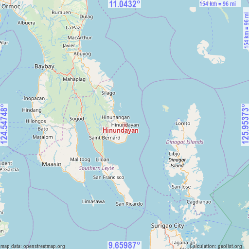
Hinundayan GPS coordinates[2]
10° 21' 8.28" North, 125° 15' 2.16" East
| Map corner | latitude | longitude |
|---|---|---|
| Upper-left | 11.0432°, | 124.54748° |
| Center: | 10.3523°, | 125.2506° |
| Lower-right: | 9.65987°, | 125.95373° |
| Map W x H: | 153.8×153.8 km | = 95.6×95.6mi |
| max Lat: | 20.78733° ⇑64.6% North |
| Hinundayan: | 10.3523° |
| min Lat: | ⇓35.4% South 4.65442° |
| min Long | Hinundayan | max Long |
| 117.04868° | 125.2506° | 126.58417° |
| W 90.7%⇐ | ⇒9.3% E |
Elevation
Elevation of Hinundayan is 3 m = 10 ft, and this is 84.9 m = 279 ft below average elevation for this country.
| Max E: |
2262 m = 7421 ft | 98.1% |
| Avg. | 87.9 m = 288 ft | |
| Hinundayan | 3 m = 10 ft | |
Min E: |
-2 m = -7 ft | 1.9% |
See also: Philippines elevation on elevation.city.
Geographical zone
Hinundayan is located in North Torrid zone (between Equator and Tropic of Cancer). Distance of Equator is 1151.1 km =715.3 mi to South.| Distance of | km | miles | from Hinundayan |
|---|---|---|---|
| North Pole | 8856 | 5502.9 | to North |
| Arctic Circle | 6250.1 | 3883.6 | to North |
| Tropic Cancer | 1454.9 | 904 | to North |
| Equator | 1151.1 | 715.3 | to South |


Nearby cities:
15 places around Hinundayan: (largest is in red/bold)
• Anahawan
8.4 km =5.2 mi,  171°
171°
• Bontoc
30.7 km =19.1 mi,  270°
270°
• Hingatungan
26.7 km =16.6 mi,  344°
344°
• Hinunangan
7.4 km =4.6 mi,  308°
308°
• Libagon
22.1 km =13.7 mi,  254°
254°
• Liloan
26 km =16.2 mi,  213°
213°
• Loreto
35.3 km =21.9 mi,  87°
87°
• Malitbog
34.8 km =21.6 mi,  232°
232°
• Saint Bernard
10.6 km =6.6 mi,  223°
223°
• San Francisco
34 km =21.1 mi,  196°
196°
• San Juan
12.5 km =7.8 mi, 220°
• Silago
21.9 km =13.6 mi,  333°
333°
• Sogod
29.7 km =18.5 mi,  276°
276°
• Tomas Oppus
31.4 km =19.5 mi, 248°
• Tubajon
34.1 km =21.2 mi, 93°
Sources, notices
• [Note1] Compared only with cities in Philippines existing in our database
• [Src1] Map data: © OpenStreetMap contributors (CC-BY-SA)
• [Src2] Other city data from geonames.org with taken over terms of usage.
• [Src3] Geographical zone / Annual Mean Temperature by Robert A. Rohde @ Wikipedia
