Silago geodata
Silago (Eastern Visayas) is a seat of a third-order administrative division; located in Philippines in Asia/Manila (GMT+8) time zone. With population of 2,276 people, there are 3730 cities with bigger population in this country. Compared to other cities in Philippines, 62.8% of cities are located further ↑North; 89.9% of cities are located further ←West and 89.7% of cities have higher elevation than Silago. Note1
Administrative division(s):
- Level 1: Eastern Visayas
- Level 2: Province of Southern Leyte
- Level 3: Silago


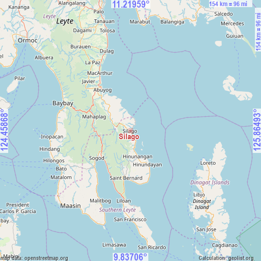
Silago GPS coordinates[2]
10° 31' 44.76" North, 125° 9' 42.48" East
| Map corner | latitude | longitude |
|---|---|---|
| Upper-left | 11.21959°, | 124.45868° |
| Center: | 10.5291°, | 125.1618° |
| Lower-right: | 9.83706°, | 125.86493° |
| Map W x H: | 153.7×153.7 km | = 95.5×95.5mi |
| max Lat: | 20.78733° ⇑62.8% North |
| Silago: | 10.5291° |
| min Lat: | ⇓37.2% South 4.65442° |
| min Long | Silago | max Long |
| 117.04868° | 125.1618° | 126.58417° |
| W 89.9%⇐ | ⇒10.1% E |
Elevation
Elevation of Silago is 7 m = 23 ft, and this is 80.9 m = 265 ft below average elevation for this country.
| Max E: |
2262 m = 7421 ft | 89.7% |
| Avg. | 87.9 m = 288 ft | |
| Silago | 7 m = 23 ft | |
Min E: |
-2 m = -7 ft | 10.3% |
See also: Philippines elevation on elevation.city.
Geographical zone
Silago is located in North Torrid zone (between Equator and Tropic of Cancer). Distance of Equator is 1170.7 km =727.4 mi to South.| Distance of | km | miles | from Silago |
|---|---|---|---|
| North Pole | 8836.3 | 5490.6 | to North |
| Arctic Circle | 6230.4 | 3871.4 | to North |
| Tropic Cancer | 1435.2 | 891.8 | to North |
| Equator | 1170.7 | 727.4 | to South |


Nearby cities:
15 places around Silago: (largest is in red/bold)
• Abuyog
29.3 km =18.2 mi,  325°
325°
• Anahawan
30.1 km =18.7 mi,  158°
158°
• Balinsacayao
27.8 km =17.3 mi,  307°
307°
• Balocawehay
30.2 km =18.8 mi,  315°
315°
• Bontoc
28.5 km =17.7 mi,  227°
227°
• Hingatungan
6.6 km =4.1 mi,  22°
22°
• Hinunangan
15.5 km =9.6 mi,  165°
165°
• Hinundayan
21.9 km =13.6 mi,  153°
153°
• Libagon
27.9 km =17.3 mi,  204°
204°
• Mahaplag
23.1 km =14.4 mi,  291°
291°
• Polahongon
21 km =13 mi,  269°
269°
• Saint Bernard
27.4 km =17 mi,  175°
175°
• San Juan
29.2 km =18.1 mi, 177°
• Sogod
25.4 km =15.8 mi, 230°
• Tomas Oppus
36.6 km =22.7 mi,  212°
212°
Sources, notices
• [Note1] Compared only with cities in Philippines existing in our database
• [Src1] Map data: © OpenStreetMap contributors (CC-BY-SA)
• [Src2] Other city data from geonames.org with taken over terms of usage.
• [Src3] Geographical zone / Annual Mean Temperature by Robert A. Rohde @ Wikipedia
