Guijalo geodata
Guijalo (Bicol) is a populated place; located in Philippines in Asia/Manila (GMT+8) time zone. With population of 2,604 people, there are 3100 cities with bigger population in this country. Compared to other cities in Philippines, 64.8% of cities are located further ↓South; 69% of cities are located further ←West and 98.1% of cities have higher elevation than Guijalo. Note1


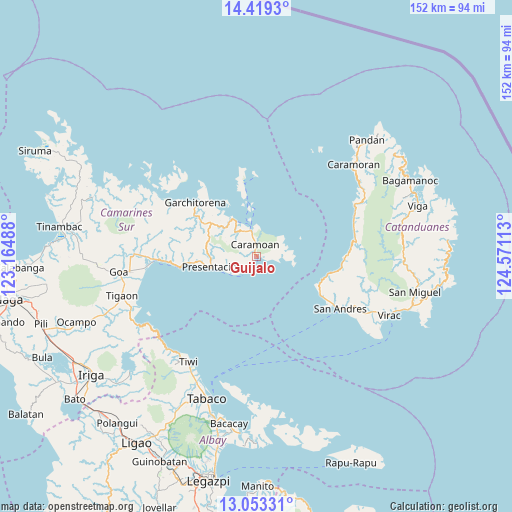
Guijalo GPS coordinates[2]
13° 44' 14.28" North, 123° 52' 4.8" East
| Map corner | latitude | longitude |
|---|---|---|
| Upper-left | 14.4193°, | 123.16488° |
| Center: | 13.7373°, | 123.868° |
| Lower-right: | 13.05331°, | 124.57113° |
| Map W x H: | 151.9×151.9 km | = 94.4×94.4mi |
| max Lat: | 20.78733° ⇑35.2% North |
| Guijalo: | 13.7373° |
| min Lat: | ⇓64.8% South 4.65442° |
| min Long | Guijalo | max Long |
| 117.04868° | 123.868° | 126.58417° |
| W 69%⇐ | ⇒31% E |
Elevation
Elevation of Guijalo is 3 m = 10 ft, and this is 84.9 m = 279 ft below average elevation for this country.
| Max E: |
2262 m = 7421 ft | 98.1% |
| Avg. | 87.9 m = 288 ft | |
| Guijalo | 3 m = 10 ft | |
Min E: |
-2 m = -7 ft | 1.9% |
See also: Philippines elevation on elevation.city.
Geographical zone
Guijalo is located in North Torrid zone (between Equator and Tropic of Cancer). Distance of this Northern Tropic circle is 1078.5 km =670.1 mi to North.| Distance of | km | miles | from Guijalo |
|---|---|---|---|
| North Pole | 8479.6 | 5269 | to North |
| Arctic Circle | 5873.7 | 3649.7 | to North |
| Tropic Cancer | 1078.5 | 670.1 | to North |
| Equator | 1527.4 | 949.1 | to South |


Nearby cities:
15 places around Guijalo: (largest is in red/bold)
• Cabcab
23.3 km =14.5 mi,  121°
121°
• Calolbon
29.5 km =18.3 mi, 122°
• Caramoan
3.8 km =2.4 mi,  351°
351°
• Garchitorena
24.6 km =15.3 mi,  310°
310°
• Gibgos
17.3 km =10.7 mi,  321°
321°
• Kinalansan
34.2 km =21.3 mi,  263°
263°
• Maagnas
21.7 km =13.5 mi, 264°
• Manamrag
25.8 km =16 mi,  90°
90°
• Parabcan
13.7 km =8.5 mi, 256°
• Sabang
31.4 km =19.5 mi,  266°
266°
• San Andres
29.3 km =18.2 mi, 121°
• San Ramon
35.5 km =22.1 mi, 267°
• San Sebastian
29.6 km =18.4 mi, 268°
• Tiwi
37 km =23 mi,  213°
213°
• Tubli
37.2 km =23.1 mi,  54°
54°
Sources, notices
• [Note1] Compared only with cities in Philippines existing in our database
• [Src1] Map data: © OpenStreetMap contributors (CC-BY-SA)
• [Src2] Other city data from geonames.org with taken over terms of usage.
• [Src3] Geographical zone / Annual Mean Temperature by Robert A. Rohde @ Wikipedia
