Caramoan geodata
Caramoan (Bicol) is a seat of a third-order administrative division; located in Philippines in Asia/Manila (GMT+8) time zone. With population of 3,471 people, there are 2075 cities with bigger population in this country. Compared to other cities in Philippines, 65.1% of cities are located further ↓South; 68.9% of cities are located further ←West and 65.1% of cities have higher elevation than Caramoan. Note1


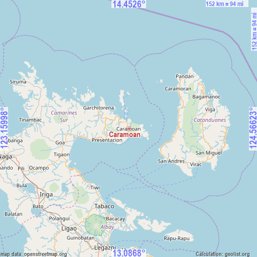
Caramoan GPS coordinates[2]
13° 46' 14.52" North, 123° 51' 47.16" East
| Map corner | latitude | longitude |
|---|---|---|
| Upper-left | 14.4526°, | 123.15998° |
| Center: | 13.7707°, | 123.8631° |
| Lower-right: | 13.0868°, | 124.56623° |
| Map W x H: | 151.9×151.9 km | = 94.4×94.4mi |
| max Lat: | 20.78733° ⇑34.9% North |
| Caramoan: | 13.7707° |
| min Lat: | ⇓65.1% South 4.65442° |
| min Long | Caramoan | max Long |
| 117.04868° | 123.8631° | 126.58417° |
| W 68.9%⇐ | ⇒31.1% E |
Elevation
Elevation of Caramoan is 14 m = 46 ft, and this is 73.9 m = 242 ft below average elevation for this country.
| Max E: |
2262 m = 7421 ft | 65.1% |
| Avg. | 87.9 m = 288 ft | |
| Caramoan | 14 m = 46 ft | |
Min E: |
-2 m = -7 ft | 34.9% |
See also: Philippines elevation on elevation.city.
Geographical zone
Caramoan is located in North Torrid zone (between Equator and Tropic of Cancer). Distance of this Northern Tropic circle is 1074.8 km =667.8 mi to North.| Distance of | km | miles | from Caramoan |
|---|---|---|---|
| North Pole | 8475.9 | 5266.7 | to North |
| Arctic Circle | 5870 | 3647.4 | to North |
| Tropic Cancer | 1074.8 | 667.8 | to North |
| Equator | 1531.2 | 951.4 | to South |


Nearby cities:
15 places around Caramoan: (largest is in red/bold)
• Cabcab
25.9 km =16.1 mi,  128°
128°
• Calolbon
32.1 km =19.9 mi, 127°
• Garchitorena
21.9 km =13.6 mi,  303°
303°
• Gibgos
14.2 km =8.8 mi,  313°
313°
• Guijalo
3.8 km =2.4 mi,  171°
171°
• Kinalansan
34.3 km =21.3 mi,  257°
257°
• Lagonoy
37.2 km =23.1 mi, 263°
• Maagnas
21.9 km =13.6 mi,  254°
254°
• Manamrag
26.6 km =16.5 mi,  98°
98°
• Parabcan
14.5 km =9 mi,  241°
241°
• Sabang
31.3 km =19.4 mi, 259°
• San Andres
31.9 km =19.8 mi, 126°
• San Ramon
35.3 km =21.9 mi, 261°
• San Sebastian
29.5 km =18.3 mi, 260°
• Tubli
35.6 km =22.1 mi,  59°
59°
Sources, notices
• [Note1] Compared only with cities in Philippines existing in our database
• [Src1] Map data: © OpenStreetMap contributors (CC-BY-SA)
• [Src2] Other city data from geonames.org with taken over terms of usage.
• [Src3] Geographical zone / Annual Mean Temperature by Robert A. Rohde @ Wikipedia
